IMAGES TAKEN NEAR TO
Kimberley Street, WYMONDHAM, NR18 0NU
Introduction
This page details the photographs taken nearby to Kimberley Street, NR18 0NU by members of the Geograph project.
The Geograph project started in 2005 with the aim of publishing, organising and preserving representative images for every square kilometre of Great Britain, Ireland and the Isle of Man.

There are currently over 7.5m images from over14,400 individuals and you can help contribute to the project by visiting https://www.geograph.org.uk
Image Map
Images are licensed for reuse under creativecommons.org/licenses/by-sa/2.0
Notes
- Clicking on the map will re-center to the selected point.
- The higher the marker number, the further away the image location is from the centre of the postcode.
Image Listing (91 Images Found)
Images are licensed for reuse under creativecommons.org/licenses/by-sa/2.0
Image
Details
Distance
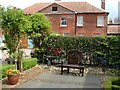
2
Courtroom wall, Wymondham Heritage Museum
Image: © Paul Shreeve
Taken: 2 May 2009
0.02 miles
3
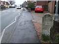
To Norwich 9
Old milestone Wymondham, Norfolk. For close up view see http://www.geograph.org.uk/photo/1166777 This is one of a series of mileposts that follow the A11 see http://www.geograph.org.uk/search.php?i=5498676
Image: © Keith Evans
Taken: 17 Feb 2009
0.03 miles
4
Old Milestone
Old milestone Wymondham, Norfolk. For overall view see http://www.geograph.org.uk/photo/1166785
Image: © Keith Evans
Taken: 17 Feb 2009
0.04 miles
5
Wymondham Heritage Museum (The Bridewell)
This museum was formerly a police station and courthouse, and originally a prison (Bridewell).
Image: © Paul Shreeve
Taken: 2 May 2009
0.04 miles
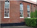
6
Bridewell Museum, Wymondham
'Bridewell' is a term for a prison that dates back to the time of Henry VIII. This building in Wymondham has been used as a women's prison, a police station and magistrate's court. It now houses the town's museum.
Image: © Stephen McKay
Taken: 20 Mar 2011
0.05 miles
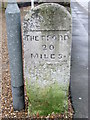
7
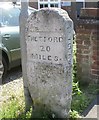
Old Milestone by Norwich Road, Wymondham
Carved stone post by the UC road, in parish of WYMONDHAM (SOUTH NORFOLK District), Norwich Road, by Red Cross shop, North of Bridewell Museum, rear of pavement, on East side of road. Thetford wedge, erected by the Thetford (to Norwich) turnpike trust in the 19th century.
Inscription reads:-
: THETFORD / 20 / MILES : : ATTLEBORO 6 M : : NORWICH / 9 / MILES :
Norfolk HER listed.
NHER Number: 56350 https://www.heritagegateway.org.uk/Gateway/Results_Single.aspx?uid=MNF62761&resourceID=1002
Milestone Society National ID: NO_NT09.
Image: © CW Haines
Taken: 2 Mar 2004
0.05 miles
8

Browick Road School, Wymondham
This was the original Victorian school for Wymondham. It is currently an infant school.
Image: © Paul Shreeve
Taken: 2 May 2009
0.06 miles
9

Wymondham Heritage Museum
Was the local prison or bridewell. The present building dates from the 1780s. It closed as a prison in 1878.
Image: © JThomas
Taken: 19 Aug 2017
0.06 miles
10
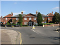
The Bridewell, Wymondham
A former prison, now housing the Heritage Museum: http://www.wymondhamheritagemuseum.co.uk/?p=the.bridewell
Image: © Evelyn Simak
Taken: 23 Sep 2011
0.06 miles