IMAGES TAKEN NEAR TO
Estelle Way, WYMONDHAM, NR18 0ES
Introduction
This page details the photographs taken nearby to Estelle Way, NR18 0ES by members of the Geograph project.
The Geograph project started in 2005 with the aim of publishing, organising and preserving representative images for every square kilometre of Great Britain, Ireland and the Isle of Man.

There are currently over 7.5m images from over14,400 individuals and you can help contribute to the project by visiting https://www.geograph.org.uk
Image Map
Images are licensed for reuse under creativecommons.org/licenses/by-sa/2.0
Notes
- Clicking on the map will re-center to the selected point.
- The higher the marker number, the further away the image location is from the centre of the postcode.
Image Listing (15 Images Found)
Images are licensed for reuse under creativecommons.org/licenses/by-sa/2.0
Image
Details
Distance
4
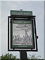
Hanging sign for The Robert Kett public house
https://www.geograph.org.uk/photo/6190085
Image: © Adrian S Pye
Taken: 23 Jun 2019
0.20 miles
5
The Robert Kett on Lime Tree Avenue, Wymondham
https://www.geograph.org.uk/photo/6189988
Image: © Adrian S Pye
Taken: 23 Jun 2019
0.20 miles
6

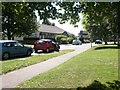
Lime Tree Avenue, Wymondham, Norfolk
A close-up of the post box can be seen in Image
Image: © habiloid
Taken: 26 Mar 2024
0.21 miles
7
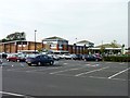
Supermarket car park
Car park at Waitrose supermarket, Wymondham.
Image: © James Allan
Taken: 22 Sep 2010
0.21 miles
8
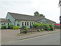
Local shops, Wymondham
This parade is on Lime Tree Avenue, in an area of estates relatively far from the town centre shops.
Image: © Katy Walters
Taken: 29 Aug 2005
0.22 miles
9
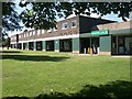
Robert Kett pub, Wymondham
This pub serves the housing estates around it rather than passing trade.
Image: © Katy Walters
Taken: 29 Aug 2005
0.22 miles
10

Post box, Lime Tree Avenue, Wymondham, Norfolk
This post box can be seen in context in Image
Image: © habiloid
Taken: 26 Mar 2024
0.22 miles