IMAGES TAKEN NEAR TO
Abbot Close, WYMONDHAM, NR18 0EG
Introduction
This page details the photographs taken nearby to Abbot Close, NR18 0EG by members of the Geograph project.
The Geograph project started in 2005 with the aim of publishing, organising and preserving representative images for every square kilometre of Great Britain, Ireland and the Isle of Man.

There are currently over 7.5m images from over14,400 individuals and you can help contribute to the project by visiting https://www.geograph.org.uk
Image Map
Images are licensed for reuse under creativecommons.org/licenses/by-sa/2.0
Notes
- Clicking on the map will re-center to the selected point.
- The higher the marker number, the further away the image location is from the centre of the postcode.
Image Listing (4 Images Found)
Images are licensed for reuse under creativecommons.org/licenses/by-sa/2.0
Image
Details
Distance
1
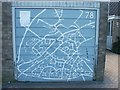
Garage door map, Wymondham
Some kind soul has painted a map of the town on their garage door - it's in the middle of a housing estate but there were two people finding it useful when I passed!
Image: © Katy Walters
Taken: 29 Aug 2005
0.10 miles
2
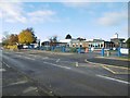
Wymondham, primary school
Robert Kett Primary School, on Hewitts Lane: http://www.robertkett.norfolk.sch.uk/
Image: © Mike Faherty
Taken: 6 Nov 2016
0.17 miles
4
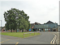
Ashleigh Primary School and Nursery
Primary school and nursery
Image: © Adrian S Pye
Taken: 23 Jun 2019
0.24 miles