IMAGES TAKEN NEAR TO
Westwood Gardens, WYMONDHAM, NR18 0DP
Introduction
This page details the photographs taken nearby to Westwood Gardens, NR18 0DP by members of the Geograph project.
The Geograph project started in 2005 with the aim of publishing, organising and preserving representative images for every square kilometre of Great Britain, Ireland and the Isle of Man.

There are currently over 7.5m images from over14,400 individuals and you can help contribute to the project by visiting https://www.geograph.org.uk
Image Map
Images are licensed for reuse under creativecommons.org/licenses/by-sa/2.0
Notes
- Clicking on the map will re-center to the selected point.
- The higher the marker number, the further away the image location is from the centre of the postcode.
Image Listing (58 Images Found)
Images are licensed for reuse under creativecommons.org/licenses/by-sa/2.0
Image
Details
Distance

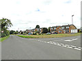
9
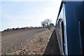
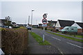
Leaving Wymondham
The B1135 passes over the railway and houses show the end of habitation before farmland. This was taken at the 2010 spring diesel gala.
Image: © Ashley Dace
Taken: 19 Mar 2010
0.12 miles