IMAGES TAKEN NEAR TO
The Turnpike, NORWICH, NR16 1RX
Introduction
This page details the photographs taken nearby to The Turnpike, NR16 1RX by members of the Geograph project.
The Geograph project started in 2005 with the aim of publishing, organising and preserving representative images for every square kilometre of Great Britain, Ireland and the Isle of Man.

There are currently over 7.5m images from over14,400 individuals and you can help contribute to the project by visiting https://www.geograph.org.uk
Image Map
Images are licensed for reuse under creativecommons.org/licenses/by-sa/2.0
Notes
- Clicking on the map will re-center to the selected point.
- The higher the marker number, the further away the image location is from the centre of the postcode.
Image Listing (16 Images Found)
Images are licensed for reuse under creativecommons.org/licenses/by-sa/2.0
Image
Details
Distance
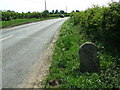
1

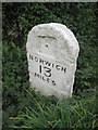
Old Milestone by the B1113, north of Hargate, Carleton Rode parish
Carved stone post by the B1113, in parish of CARLETON RODE (SOUTH NORFOLK District), 12yds South of Oak Range (house), standing in shallow ditch, on West side of road. New Buckenham wedge, erected by the New Buckenham turnpike trust in the 19th century.
Inscription reads:-
: NORWICH / 13 / MILES : : NEW BUCKENHAM / 2 / MILES :
Norfolk HER.
NHER Number: 56381 https://www.heritagegateway.org.uk/Gateway/Results_Single.aspx?uid=MNF62786&resourceID=1002
Milestone Society National ID: NO_NNB13.
Image: © CW Haines
Taken: 16 Oct 2003
0.02 miles
4
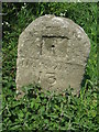
Old Milestone
Old milestone near to Hargate, Norfolk on the B1113. For overall view see http://www.geograph.org.uk/photo/1281056 more info on the post see http://milestones.megalithia.com/sites/tm121920.htm do have a look at their home page.
Image: © Keith Evans
Taken: 1 May 2009
0.03 miles
5
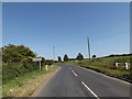
B1113 The Turnpike, Bunwell
Near Bunwell Village Name sign
Image: © Geographer
Taken: 30 Aug 2016
0.05 miles
6
Entering Bunwell on the B1113 The Turnpike
Image: © Geographer
Taken: 30 Aug 2016
0.05 miles
7
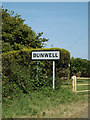
Bunwell Village Name sign on the B1113 The Turnpike
Image: © Geographer
Taken: 30 Aug 2016
0.05 miles
8
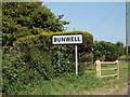
Bunwell Village Name sign on the B1113 The Turnpike
Image: © Geographer
Taken: 30 Aug 2016
0.05 miles
9
To New Buckenham 2
Old milestone near to Hargate, Norfolk on the B1113. For close up view see http://www.geograph.org.uk/photo/1281079 for more info on the post see http://milestones.megalithia.com/sites/tm121920.htm do have a look at their home page.
Image: © Keith Evans
Taken: 1 May 2009
0.06 miles
10
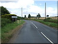
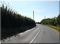
The Turnpike (B1113)
Heading north east towards Norwich.
Image: © JThomas
Taken: 25 Jul 2015
0.07 miles