IMAGES TAKEN NEAR TO
Seething Street, NORWICH, NR15 1DN
Introduction
This page details the photographs taken nearby to Seething Street, NR15 1DN by members of the Geograph project.
The Geograph project started in 2005 with the aim of publishing, organising and preserving representative images for every square kilometre of Great Britain, Ireland and the Isle of Man.

There are currently over 7.5m images from over14,400 individuals and you can help contribute to the project by visiting https://www.geograph.org.uk
Image Map
Images are licensed for reuse under creativecommons.org/licenses/by-sa/2.0
Notes
- Clicking on the map will re-center to the selected point.
- The higher the marker number, the further away the image location is from the centre of the postcode.
Image Listing (247 Images Found)
Images are licensed for reuse under creativecommons.org/licenses/by-sa/2.0
Image
Details
Distance
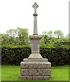
1
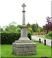
The war memorial in Seething
For a close-up view of the names of the commemorated see > http://www.geograph.org.uk/photo/4491743 and http://www.geograph.org.uk/photo/4491739.
Image: © Evelyn Simak
Taken: 25 May 2015
0.01 miles
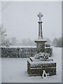
2
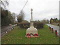
Seething War Memorial
Seething War Memorial is located at a Y junction south of the church.
It bears the five names of the Seething men who fell in the Great War and also the names of four men who died in the Second World War, one of whom is buried in the churchyard, and another at Mundham, the adjoining parish.
Image: © Adrian S Pye
Taken: 7 Jan 2019
0.02 miles
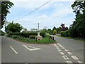
3
Seething War Memorial
Off School Road at the junction with Seething Street
Image: © Geographer
Taken: 11 Sep 2014
0.02 miles
4
Seething Street & Seething War Memorial
At the junction with School Road
Road No.C372
Image: © Geographer
Taken: 11 Sep 2014
0.02 miles
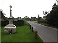
5
The war memorial in Seething
It is situated in the triangle by the junction of School Road and Seething Street. The church of St Margaret and St Remigius > http://www.geograph.org.uk/photo/1313326 can be glimpsed in the background. For a close-up view of the names of the commemorated see > http://www.geograph.org.uk/photo/4491743 and http://www.geograph.org.uk/photo/4491739.
Image: © Evelyn Simak
Taken: 25 May 2015
0.02 miles
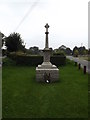
6
Seething war memorial at junction of School Road and Seething Street
Image: © Roy Hughes
Taken: 14 May 2022
0.02 miles
7
The war memorial at Seething
War memorial and church (in the distance)
Image: © Ashley Dace
Taken: 23 Nov 2008
0.02 miles
8
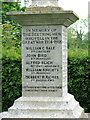
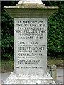
The war memorial in Seething (names)
For a full view of the memorial which is situated in the triangle by the junction of School Road and Seething Street see > http://www.geograph.org.uk/photo/4491731.
Image: © Evelyn Simak
Taken: 25 May 2015
0.02 miles
9
The war memorial in Seething (names)
For a full view of the memorial which is situated in the triangle by the junction of School Road and Seething Street see > http://www.geograph.org.uk/photo/4491731.
Image: © Evelyn Simak
Taken: 25 May 2015
0.02 miles
