
IMAGES TAKEN NEAR TO
Gas Hill, NORWICH, NR1 4JB
Introduction
This page details the photographs taken nearby to Gas Hill, NR1 4JB by members of the Geograph project.
The Geograph project started in 2005 with the aim of publishing, organising and preserving representative images for every square kilometre of Great Britain, Ireland and the Isle of Man.

There are currently over 7.5m images from over14,400 individuals and you can help contribute to the project by visiting https://www.geograph.org.uk
Image Map
Images are licensed for reuse under creativecommons.org/licenses/by-sa/2.0
Notes
- Clicking on the map will re-center to the selected point.
- The higher the marker number, the further away the image location is from the centre of the postcode.
Image Listing (1094 Images Found)
Images are licensed for reuse under creativecommons.org/licenses/by-sa/2.0
Image
Details
Distance
1

GoGoHares - Break Harepower
For 11 weeks during the summer of 2018, 50 beautifully painted hare sculptures are on display at strategic locations in the city of Norwich. The sculptures will be sold by auction in September, with the proceeds going to the Norfolk charity 'Break'. This hare is sponsored by Wilco Motor Spares. It was painted by Joanne Botterill, inspired by the mechanics of cars. The design includes many real car parts along some hare-specific body work. 'Break Harepower' can be seen at Bishopgate.
Image: © Evelyn Simak
Taken: 26 Jun 2018
0.01 miles
2

Gas Hill on the corner of William Kett Close
Kett's Rebellion (1549) was led by Robert Kett and his brother William Kett. Opposed to the deprivation of the poor when common land was enclosed for sheep, they camped on Mousehold Heath at the top of this hill for months in the summer until they were defeated in battle by the Earl of Warwick's army. The Ketts were both hanged.
Image: © Vieve Forward
Taken: 24 May 2022
0.01 miles
3

Lollards pit (plaque)
The plaque can be seen on the wall of the Lollard's Pit public house > https://www.geograph.org.uk/photo/5776392.
Image: © Evelyn Simak
Taken: 26 Jun 2018
0.01 miles
4

The Lollards Pit public house as seen from Gas Hill
This Grade 2 listed 15th century former dwelling house with later alterations and extensions later became a pub originally called the King's Arms Inn (to 1975) and in the 1990s became the Bridge House public house, with originally comprising three rooms, a bar snug and a living room. It is currently trading as the Lollards Pit (from 2012) > https://www.geograph.org.uk/photo/5776390 due to its close vicinity to this location. Legend has it that the building was once used as a women's prison and that it is haunted by the ghost of a woman. For a view of the pub sign see > https://www.geograph.org.uk/photo/5776390.
The nearby location known as the Lollards Pit, after which the pub is named, was a site chosen in the mid-16th century for the execution by burning of heretics. It was an old chalk pit on the edge of the Thorpe Woods, approximately opposite Bishop Bridge (where the Lollard's Pit public house is also situated), which in 1544 had been leased to John Goldyng. Long after the location had ceased to be used for executions it was considered an evil place and avoided by people, but by the 19th century it said to have become a camp site for travellers. The pit has since been built over.
Image: © Evelyn Simak
Taken: 5 Sep 2019
0.01 miles

6

The Lollards Pit public house
Formerly known as The Bridge House Image, in 2012 the pub reopened, having been renamed after the site on which it stands = a place of execution for heretics and other offenders in the 16th century.
Image: © Rod Allday
Taken: 20 May 2013
0.01 miles
7

Lollards Pit (pub)
Across the road from Bishop Bridge.
Image: © Robin Webster
Taken: 27 Dec 2013
0.01 miles
8
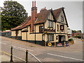
Lollards Pit
Lollards Pit on Riverside Road was the site of a place of execution for heretics (Lollards) and other offenders in the 15th and 16th centuries. The pit was created when early chalk workings were dug out there to provide foundations for the nearby cathedral.
The public house which occupies the site was built between 1620 and 1670. It was called The Kings Arms until 1975 It was then known as The Bridge House until June 2012 when it was restored and renamed “Lollards Pit” (http://goo.gl/vm14Be Eastern Daily Press).
During restoration several features of the original building were revealed including the holding cell in what is now the pub’s cellar, used to hold prisoners before they were led to the pit to be burnt at the stake. (http://www.perfectpint.co.uk/pubs/lollards-pit-norwich#t2 pub website).
The pub is a grade II listed building (English Heritage Building ID: 229457 http://www.britishlistedbuildings.co.uk/en-229457-bridge-house-public-house-norfolk#.VjzKGXknyHs British Listed Buildings).
Image: © David Dixon
Taken: 7 Aug 2015
0.01 miles
9

The Lollards Pit public house, Norwich
On Riverside Road.
Image: © JThomas
Taken: 25 Apr 2016
0.01 miles
10

A pleasant stroll from Norwich Cathedral to Riverside Road (o)
Note the old gasworks
Image: © Basher Eyre
Taken: 17 Jun 2017
0.01 miles