IMAGES TAKEN NEAR TO
Thrush Close, NORWICH, NR14 8JF
Introduction
This page details the photographs taken nearby to Thrush Close, NR14 8JF by members of the Geograph project.
The Geograph project started in 2005 with the aim of publishing, organising and preserving representative images for every square kilometre of Great Britain, Ireland and the Isle of Man.

There are currently over 7.5m images from over14,400 individuals and you can help contribute to the project by visiting https://www.geograph.org.uk
Image Map
Images are licensed for reuse under creativecommons.org/licenses/by-sa/2.0
Notes
- Clicking on the map will re-center to the selected point.
- The higher the marker number, the further away the image location is from the centre of the postcode.
Image Listing (18 Images Found)
Images are licensed for reuse under creativecommons.org/licenses/by-sa/2.0
Image
Details
Distance
1
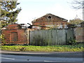
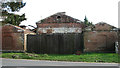
The Old Forge Mulbarton
Viewed from the Norwich Road. Despite its dilapidated appearance, the current owner has carried out sympathetic repairs over the years and the general structure is extremely sound.
Image: © Joe Harris
Taken: 31 Oct 2008
0.08 miles
2
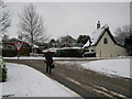
East Carleton Road looking east
East Carleton Road looking east towards the junction with the B1113. The Old Forge can be seen across the road to the left.
The area adjacent to the figure was originally the site of The Tradesman's Arms and four cottages, contentiously demolished in the seventies and replaced with undistinguished housing.
Image: © Joe Harris
Taken: 23 Nov 2008
0.08 miles
3
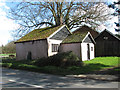
Norwich Road past the old forge
This long disused smithy > http://www.geograph.org.uk/photo/5319519 which dates from around 1830, may once have been part of the Bracon Hall estate. It is brick built to a symmetrical plan with a pair of forewings and a pantiled roof. There are two blind windows at the forewing gable ends, beneath skewback arches with cambered soffits and an oculus in the main pediment. The building is Grade II listed.
Image: © Evelyn Simak
Taken: 21 Mar 2017
0.09 miles
5
The old forge in Mulbarton
This long disused smithy, which dates from around 1830, may once have been part of the Bracon Hall estate. It is brick built to a symmetrical plan with a pair of forewings and a pantiled roof. There are two blind windows at the forewing gable ends, beneath skewback arches with cambered soffits and an oculus in the main pediment. The building is Grade II listed.
Image: © Evelyn Simak
Taken: 21 Mar 2017
0.09 miles
6
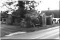
Disused building beside Norwich Road
It is located adjacent to the old forge.
Image: © Evelyn Simak
Taken: 21 Mar 2017
0.10 miles
7
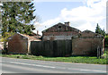
The old forge in Mulbarton
This long disused smithy, which dates from around 1830, may once have been part of the Bracon Hall estate. It is brick built to a symmetrical plan with a pair of forewings and a pantiled roof. There are two blind windows at the forewing gable ends, beneath skewback arches with cambered soffits and an oculus in the main pediment. The building is Grade II listed.
Image: © Evelyn Simak
Taken: 21 Mar 2017
0.10 miles
8
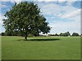
Mulbarton Common
The large common seen from the south - the distant church is in TG1901.
Image: © Katy Walters
Taken: 28 Aug 2005
0.11 miles
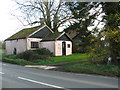
9
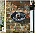
The Malt House (sign)
For a view of this building see > http://www.geograph.org.uk/photo/5319562.
Image: © Evelyn Simak
Taken: 21 Mar 2017
0.11 miles
10
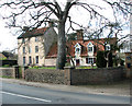
The Malt House in Mulbarton
The Grade II listed one-storeyed cottage seen at right dates from the 17th century; the tall part at left was added in the early 19th century. The building is timber-framed refaced with brick and has pantiled roofs.
Image: © Evelyn Simak
Taken: 21 Mar 2017
0.11 miles