IMAGES TAKEN NEAR TO
Bligh Close, NORWICH, NR14 7SF
Introduction
This page details the photographs taken nearby to Bligh Close, NR14 7SF by members of the Geograph project.
The Geograph project started in 2005 with the aim of publishing, organising and preserving representative images for every square kilometre of Great Britain, Ireland and the Isle of Man.

There are currently over 7.5m images from over14,400 individuals and you can help contribute to the project by visiting https://www.geograph.org.uk
Image Map
Images are licensed for reuse under creativecommons.org/licenses/by-sa/2.0
Notes
- Clicking on the map will re-center to the selected point.
- The higher the marker number, the further away the image location is from the centre of the postcode.
Image Listing (79 Images Found)
Images are licensed for reuse under creativecommons.org/licenses/by-sa/2.0
Image
Details
Distance
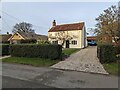
2
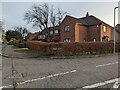
Apple Tree Cottage, Hall Road, Poringland
Image: © TCExplorer
Taken: 26 Dec 2023
0.06 miles
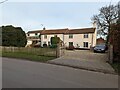
3
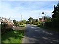
Long Road, Framingham Earl
At the junction with Hall Road
Image: © Geographer
Taken: 12 Apr 2013
0.09 miles
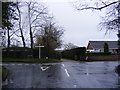
4
Hall Road, Framingham Earl
At the junction with Long Road
Image: © Geographer
Taken: 12 Apr 2013
0.09 miles
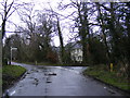
6
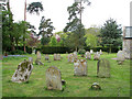
St Andrew's church - churchyard
See > http://www.geograph.org.uk/photo/1284635 for a view of the church.
Image: © Evelyn Simak
Taken: 3 May 2009
0.14 miles
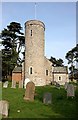
7
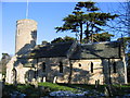
St. Andrew's, Framingham Earl
For more information see http://www.poringland-benefice.org.uk/ and http://www.norfolkchurches.co.uk/framinghamearl/framinghamearl.htm
Image: © Graham Hardy
Taken: 4 Mar 2006
0.15 miles
10
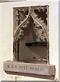
St Andrew, Framingham Earl, Norfolk - Piscina
Image: © John Salmon
Taken: 25 Apr 2009
0.18 miles