IMAGES TAKEN NEAR TO
Framingham Lane, NORWICH, NR14 7HF
Introduction
This page details the photographs taken nearby to Framingham Lane, NR14 7HF by members of the Geograph project.
The Geograph project started in 2005 with the aim of publishing, organising and preserving representative images for every square kilometre of Great Britain, Ireland and the Isle of Man.

There are currently over 7.5m images from over14,400 individuals and you can help contribute to the project by visiting https://www.geograph.org.uk
Image Map
Images are licensed for reuse under creativecommons.org/licenses/by-sa/2.0
Notes
- Clicking on the map will re-center to the selected point.
- The higher the marker number, the further away the image location is from the centre of the postcode.
Image Listing (20 Images Found)
Images are licensed for reuse under creativecommons.org/licenses/by-sa/2.0
Image
Details
Distance

3
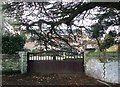
Entrance to The Grange
The Grange is a Grade 2 listed building, formerly a farmhouse, with various dates of construction but mainly C17 with C18 and later alterations. Unfortunately, the spreading branches of an ancient cedar tree obscures it from view almost entirely.
Image: © Evelyn Simak
Taken: 7 Dec 2019
0.11 miles
4

The Grange in Bramerton
The Grange is a Grade 2 listed building, formerly a farmhouse, with various dates of construction but mainly C17 with C18 and later alterations. Unfortunately, the spreading branches of an ancient cedar tree obscures it from view almost entirely.
Image: © Evelyn Simak
Taken: 7 Dec 2019
0.11 miles
6
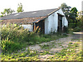
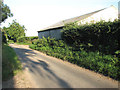
Farm shed beside footpath
This farm building is situated beside Bullockshed Lane at the start of a public footpath south to the A146 road.
Image: © Evelyn Simak
Taken: 31 Jul 2009
0.12 miles
7
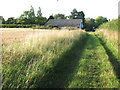
Public footpath to Bullockshed Lane
The path links Bullockshed Lane and the A146 road.
Image: © Evelyn Simak
Taken: 31 Jul 2009
0.13 miles
8

Smooth hawksbeard (Crepis capillaris)
This common and widespread plant can frequently be found growing on rocky outcrops, sandy ground and steep banks, properties that have allowed it to exploit a wide range of man-made habitats such as spoil heaps, road verges, railway cutting and other sites subject to a fair degree of disturbance.
Image: © Evelyn Simak
Taken: 1 Jun 2017
0.14 miles
9

Smooth hawksbeard (Crepis capillaris) - flowers
This common and widespread plant can frequently be found growing on rocky outcrops, sandy ground and steep banks, properties that have allowed it to exploit a wide range of man-made habitats such as spoil heaps, road verges, railway cutting and other sites subject to a fair degree of disturbance. For a wider view of this location see > http://www.geograph.org.uk/photo/5412086.
Image: © Evelyn Simak
Taken: 1 Jun 2017
0.14 miles