
IMAGES TAKEN NEAR TO
Church Hill, Beccles Road, NORWICH, NR14 6PF
Introduction
This page details the photographs taken nearby to Church Hill, Beccles Road, NR14 6PF by members of the Geograph project.
The Geograph project started in 2005 with the aim of publishing, organising and preserving representative images for every square kilometre of Great Britain, Ireland and the Isle of Man.

There are currently over 7.5m images from over14,400 individuals and you can help contribute to the project by visiting https://www.geograph.org.uk
Image Map
Images are licensed for reuse under creativecommons.org/licenses/by-sa/2.0
Notes
- Clicking on the map will re-center to the selected point.
- The higher the marker number, the further away the image location is from the centre of the postcode.
Image Listing (246 Images Found)
Images are licensed for reuse under creativecommons.org/licenses/by-sa/2.0
Image
Details
Distance
1
Rectory Lane sign
On Rectory Lane at the junction with the A143 Church Hill
Image: © Geographer
Taken: 24 Apr 2014
0.01 miles
2
A143 Church Hill, Haddiscoe
At the junction with Rectory Lane
Image: © Geographer
Taken: 24 Apr 2014
0.02 miles
3
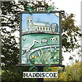
Haddiscoe village sign
The sign shows Haddiscoe church with the chequered top to the tower which makes it quite distinctive. The Haddiscoe grazing marshes are represented by the wide area of green with cows, and the grey heron. Four different species of plants are represented amongst the grass. The anvil may seem out of place on the marsh but The parish still has a working blacksmith in Daniel Johnson.
Image: © Adrian S Pye
Taken: 31 Oct 2020
0.02 miles
4
Haddiscoe village sign
The sign shows Haddiscoe church with the chequered top to the tower which makes it quite distinctive. The Haddiscoe grazing marshes are represented by the wide area of green with cows, and the grey heron. Four different species of plants are represented amongst the grass. The anvil may seem out of place on the marsh but The parish still has a working blacksmith in Daniel Johnson.
For a closer look at the sign click the https://www.geograph.org.uk/photo/6659730
Image: © Adrian S Pye
Taken: 31 Oct 2020
0.02 miles
5
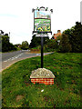
Haddiscoe Village sign
Off the A143 Church Hill between the junctions with Rectory Lane & Church Lane
Image: © Geographer
Taken: 24 Apr 2014
0.03 miles
6
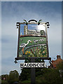
Haddiscoe Village sign
Off the A143 Church Hill between the junctions with Rectory Lane & Church Lane
Image: © Geographer
Taken: 24 Apr 2014
0.03 miles
7

WW2 plaque on Haddiscoe War Memorial
The plaque bears the names of seven men, two of whom died after the war from injuries received in action.
It is attached to the base of the War Memorial in the churchyard https://www.geograph.org.uk/photo/4487116
Image: © Adrian S Pye
Taken: 19 May 2015
0.03 miles
8
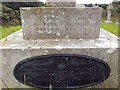
Names of the Fallen on Haddiscoe War Memorial 2
Close up of Image
Image: © Helen Steed
Taken: 4 Sep 2012
0.03 miles
9

Names of the Fallen on Haddiscoe War Memorial 3
Close up of Image
Image: © Helen Steed
Taken: 4 Sep 2012
0.04 miles
10

Headstone of Thomas South Mack
Thomas South Mack was born in 1904.
He was injured while serving his country in the Second World War, dying from his wounds in 1948.
His younger sister Christabel was buried with him when she died in 1959.
When a young boy he was the subject of a painting by Mia Arnesby Brown which is in Norwich museum https://artuk.org/discover/artworks/thomas-south-mack-as-a-small-boy-1260
Image: © Adrian S Pye
Taken: 18 Sep 2018
0.04 miles