IMAGES TAKEN NEAR TO
Liberator Close, NORWICH, NR13 6QX
Introduction
This page details the photographs taken nearby to Liberator Close, NR13 6QX by members of the Geograph project.
The Geograph project started in 2005 with the aim of publishing, organising and preserving representative images for every square kilometre of Great Britain, Ireland and the Isle of Man.

There are currently over 7.5m images from over14,400 individuals and you can help contribute to the project by visiting https://www.geograph.org.uk
Image Map
Images are licensed for reuse under creativecommons.org/licenses/by-sa/2.0
Notes
- Clicking on the map will re-center to the selected point.
- The higher the marker number, the further away the image location is from the centre of the postcode.
Image Listing (56 Images Found)
Images are licensed for reuse under creativecommons.org/licenses/by-sa/2.0
Image
Details
Distance
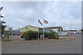
2
Liberator Close, named after the B 24 which flew from here
Image: © Adrian S Pye
Taken: 25 Jul 2020
0.04 miles
3
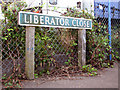
Liberator Close (road sign)
Several of the roads on the Rackheath Industrial Estate have names, commemorating RAF Rackheath which was an active airfield from which B-24 Liberator bomber aircraft were flown during WW2. The industrial estate was built on the former Technical site.
Image: © Evelyn Simak
Taken: 29 Aug 2014
0.04 miles
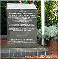
4
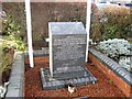
Memorial to USAAF Rackheath
Designated Station 145 USAAF Rackheath was home to the 467th Bombardment Group Heavy. 2nd Air Division, 8th Air Force, United States Army Air Force under the command of Colonel Albert J. Shower.
Flew 212 combat missions, 5538 Aircraft Sorties with losses of 235 airmen, 46 aircraft in Liberator Bombers from this airfield. From March 11th 1944 to July 5th 1945 over 5000 American airmen stationed here made a major contribution to the defeat of Nazi Germany in World War II.
Image: © Adrian S Pye
Taken: 25 Jul 2020
0.05 miles
5
Memorial to USAAF Rackheath
Designated Station 145 USAAF Rackheath was home to the 467th Bombardment Group Heavy. 2nd Air Division, 8th Air Force, United States Army Air Force under the command of Colonel Albert J. Shower.
Flew 212 combat missions, 5538 Aircraft Sorties with losses of 235 airmen, 46 aircraft in Liberator Bombers from this airfield. From March 11th 1944 to July 5th 1945 over 5000 American airmen stationed here made a major contribution to the defeat of Nazi Germany in World War II. https://www.geograph.org.uk/photo/6549026
Image: © Adrian S Pye
Taken: 25 Jul 2020
0.05 miles
6
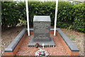
467th Bombardment Group memorial stone
The memorial is dedicated to the 467th Bombardment Group of USAAF which was stationed at RAF Rackheath when it was an active airfield during WW2. It is situated at Liberator Close, on the Rackheath Industrial Estate which occupies the area of the former Technical site. For a wider view of this location see > http://www.geograph.org.uk/photo/4143307.
Image: © Evelyn Simak
Taken: 29 Aug 2014
0.05 miles
7
View along Bidwell Road from Liberator Close
The memorial stone dedicated to the 467th Bombardment Group, which was based at RAF Rackheath when it was an active airfield during WW2, can be seen left of centre. The memorial is located on the Rackheath Industrial Estate which occupies the former Technical site. For a close-up view of the memorial stone see > http://www.geograph.org.uk/photo/4143313.
Image: © Evelyn Simak
Taken: 29 Aug 2014
0.05 miles
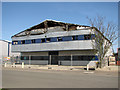
8
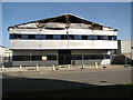
Fire-damaged business unit on the Rackheath Industrial Estate
On 29 February 2012 a fire ripped through the industrial unit housing a company called PHS Data Shred, situated on the Rackheath Industrial Estate. Altogether 13 fire engines are reported to have been at the scene and the industrial estate was closed to all but emergency vehicles. A security fence has since been erected around the burnt-out shell of the building.
Image: © Evelyn Simak
Taken: 1 Apr 2012
0.08 miles
9
Burnt-out industrial premises at Rackheath Industrial Estate
On 29 February 2012 a fire ripped through the industrial unit housing a company called PHS Data Shred, situated on the Rackheath Industrial Estate. Altogether 13 fire engines are reported to have been at the scene and the industrial estate was closed to all but emergency vehicles. A security fence has since been erected around the burnt-out shell of the building.
Image: © Evelyn Simak
Taken: 1 Apr 2012
0.08 miles
10
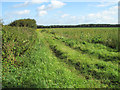
Footpath to Dakenham Hall
This public footpath links Witchcraft Way on the Rackheath Industrial Estate with Dakenham Hall, near Salhouse railway station, further to the north-east. The path traverses the former WW2 flying field of RAF Rackheath which has long since reverted to agriculture.
Image: © Evelyn Simak
Taken: 29 Aug 2014
0.10 miles