IMAGES TAKEN NEAR TO
Chameryhall Lane, NORWICH, NR13 6DU
Introduction
This page details the photographs taken nearby to Chameryhall Lane, NR13 6DU by members of the Geograph project.
The Geograph project started in 2005 with the aim of publishing, organising and preserving representative images for every square kilometre of Great Britain, Ireland and the Isle of Man.

There are currently over 7.5m images from over14,400 individuals and you can help contribute to the project by visiting https://www.geograph.org.uk
Image Map
Images are licensed for reuse under creativecommons.org/licenses/by-sa/2.0
Notes
- Clicking on the map will re-center to the selected point.
- The higher the marker number, the further away the image location is from the centre of the postcode.
Image Listing (8 Images Found)
Images are licensed for reuse under creativecommons.org/licenses/by-sa/2.0
Image
Details
Distance
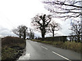
2
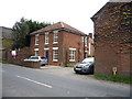
Chameryhall Lane (B1140)
Heading south east.
Image: © JThomas
Taken: 25 Apr 2016
0.12 miles
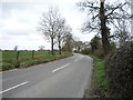
3
Heading south east from Panxworth
On the B1140.
Image: © JThomas
Taken: 25 Apr 2016
0.18 miles
4
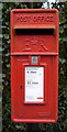
Close up, Elizabeth II postbox, Panxworth
Postbox No. NR13 1366.
See Image] for context.
Image: © JThomas
Taken: 25 Apr 2016
0.20 miles
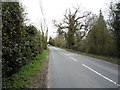
5
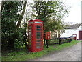
Elizabeth II postbox and telephone box, Panxworth
Postbox No, NR13 1366.
See Image] for close up.
Image: © JThomas
Taken: 25 Apr 2016
0.21 miles
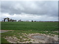
7
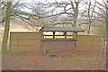
Hide at South Walsham Fen Nature Reserve
As well as the hide, the Reserve offers a pleasant stroll through the fen on a boardwalk.
Image: © Morley Sewell
Taken: 2 Apr 2009
0.22 miles