
IMAGES TAKEN NEAR TO
Tillett Way, NR13 5GL
Introduction
This page details the photographs taken nearby to Tillett Way, NR13 5GL by members of the Geograph project.
The Geograph project started in 2005 with the aim of publishing, organising and preserving representative images for every square kilometre of Great Britain, Ireland and the Isle of Man.

There are currently over 7.5m images from over14,400 individuals and you can help contribute to the project by visiting https://www.geograph.org.uk
Image Map
Images are licensed for reuse under creativecommons.org/licenses/by-sa/2.0
Notes
- Clicking on the map will re-center to the selected point.
- The higher the marker number, the further away the image location is from the centre of the postcode.
Image Listing (42 Images Found)
Images are licensed for reuse under creativecommons.org/licenses/by-sa/2.0
Image
Details
Distance
1
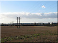
View across a stubble field
This view was taken from a public footpath which starts at Smee Lane > http://www.geograph.org.uk/photo/919906 and leads to the A47, further to the south > http://www.geograph.org.uk/photo/1068458 - http://www.geograph.org.uk/photo/1068463. The field seen in the foreground, traversed by an electricity line, adjoins the path in the west. Buildings located in the Business Park of Thorpe St Andrew can be seen in the background (at right, in adjacent grid square).
Image: © Evelyn Simak
Taken: 3 Dec 2008
0.17 miles
3
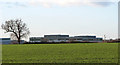
Cultivated field with winter crop
This field adjoins the path in the west. Buildings in Thorpe St Andrew's Business Park can be seen in the background (in adjacent grid square). This view was taken from the public footpath which starts at Smee Lane > http://www.geograph.org.uk/photo/919906 and leads to the A47, further to the south > http://www.geograph.org.uk/photo/1068458 - http://www.geograph.org.uk/photo/1068463.
Image: © Evelyn Simak
Taken: 3 Dec 2008
0.19 miles
4
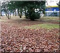
Unmarked graves
All grave markers in the disused cemetery in Memorial Way were removed by the Hospital Board and sold for scrap. The outlines of some of the graves can still be discerned, but it is no longer possible to know exactly where a particular individual is interred. One of the graves in the area depicted in the foreground is that of Mykola Zaluckyj, a Polish national who came to Thorpe St Andrew's hospital as a refugee. He died on 7 November 1951 and was buried in grave #631.
Image: © Evelyn Simak
Taken: 19 Dec 2017
0.20 miles
5

Memorial in Memorial Way
See http://www.geograph.org.uk/photo/5528891 and http://www.geograph.org.uk/photo/5528897
Image: © Adrian S Pye
Taken: 7 Sep 2017
0.20 miles
6

Memorial in Memorial Way
See http://www.geograph.org.uk/photo/5528891
Image: © Adrian S Pye
Taken: 7 Sep 2017
0.20 miles
7

Cemetery in Memorial Way Norwich
The Thorpe St. Andrew's hospital cemetery has been desecrated by the systematic removal of all headstones and grave markers. The hospital over its lifetime has served the community in many ways. It was originally built as the Norfolk County Asylum (1814 – 1915), then as the Norfolk War Hospital (1915 – 1919) followed by Norfolk Mental Hospital (1919 – 1923) and finally Thorpe St. Andrew's Hospital (1923 – 1998). During the Second World war it was again used for the troops returning wounded from the war. Among the War wounded were refugees and many who survived settled in the area. Those who didn't survive were laid to rest here along with others who died in the hospital as late as 1966.
Among the many were three Polish airmen who stayed after the war and were eventually buried in the cemetery. Their names are recorded in the Norfolk Record Office and recalled here: Mykola Zaluckyj from Huntington, buried 7 Nov 1951 aged 29. Grave # 631.
Dmytr Jeluk from Sleaford, buried 12 Oct 1955 aged 45. Grave # 657. Wladyslaw Pawel Bartnicki from Thorpe St Andrew, buried 1 Dec 1960 aged 64. Grave # 688.
Despite the hospital board being advised otherwise, in their infinite wisdom they sold all the metal grave markers for scrap to cut down on the expense of maintaining the cemetery in an appropriate manner and maintaining respect for the dead.
The cemetery contains 217 graves, most with two bodies. The first grave is no 495 and dates to the 1940s/50s, the last is no 711, dating 14 Oct 1966.
Have they no respect for the dead?
http://www.geograph.org.uk/photo/5528900 http://www.geograph.org.uk/photo/5528897
Image: © Adrian S Pye
Taken: 7 Sep 2017
0.20 miles
8

St Andrew's hospital - cemetery
The narrow green space of the cemetery is adjacent to the roundabout at the end of a short road called Memorial Way is surrounded by huge warehouses > http://www.geograph.org.uk/photo/4822151.
Image: © Evelyn Simak
Taken: 10 Feb 2016
0.20 miles
9

Memorial in disused cemetery
This view was taken looking from the western boundary of the plot towards the memorial situated roughly in the centre of the cemetery, which is surrounded by large industrial units. All graves are unmarked, due to the grave markers having been removed and sold for scrap by the Hospital Board.
Image: © Evelyn Simak
Taken: 19 Dec 2017
0.20 miles
10

St Andrew's hospital - cemetery
The narrow green space of the cemetery is adjacent to the roundabout at the end of a short road called Memorial Way is surrounded by huge warehouses > http://www.geograph.org.uk/photo/4822151.
Image: © Evelyn Simak
Taken: 10 Feb 2016
0.20 miles