IMAGES TAKEN NEAR TO
Hospital Road, NORWICH, NR13 5FH
Introduction
This page details the photographs taken nearby to Hospital Road, NR13 5FH by members of the Geograph project.
The Geograph project started in 2005 with the aim of publishing, organising and preserving representative images for every square kilometre of Great Britain, Ireland and the Isle of Man.

There are currently over 7.5m images from over14,400 individuals and you can help contribute to the project by visiting https://www.geograph.org.uk
Image Map
Images are licensed for reuse under creativecommons.org/licenses/by-sa/2.0
Notes
- Clicking on the map will re-center to the selected point.
- The higher the marker number, the further away the image location is from the centre of the postcode.
Image Listing (20 Images Found)
Images are licensed for reuse under creativecommons.org/licenses/by-sa/2.0
Image
Details
Distance
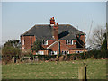
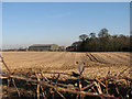
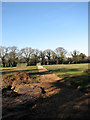
1
Manor House Farm
View towards Manor House farmhouse across pasture, from Hospital Road.
Image: © Evelyn Simak
Taken: 11 Feb 2008
0.03 miles
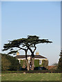
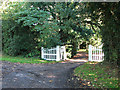
2
Approach to Manor Farm, Plumstead Green
Image: © Evelyn Simak
Taken: 24 Oct 2013
0.06 miles
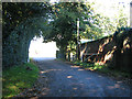
4
Agricultural sheds
Belonging to Manor House Farm.
Image: © Evelyn Simak
Taken: 11 Feb 2008
0.09 miles
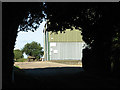
8
Newly constructed path
On a site where new offices are going to be erected. See also > Image
Image: © Evelyn Simak
Taken: 11 Feb 2008
0.14 miles
9

Manor Farm Barns, Little Plumstead
An unusual complex of Georgian farm buildings with an octagonal engine house in the centre.
Image: © Gareth Hughes
Taken: Unknown
0.15 miles