IMAGES TAKEN NEAR TO
Buckenham Lane, NORWICH, NR13 4NH
Introduction
This page details the photographs taken nearby to Buckenham Lane, NR13 4NH by members of the Geograph project.
The Geograph project started in 2005 with the aim of publishing, organising and preserving representative images for every square kilometre of Great Britain, Ireland and the Isle of Man.

There are currently over 7.5m images from over14,400 individuals and you can help contribute to the project by visiting https://www.geograph.org.uk
Image Map
Images are licensed for reuse under creativecommons.org/licenses/by-sa/2.0
Notes
- Clicking on the map will re-center to the selected point.
- The higher the marker number, the further away the image location is from the centre of the postcode.
Image Listing (8 Images Found)
Images are licensed for reuse under creativecommons.org/licenses/by-sa/2.0
Image
Details
Distance
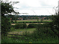
2
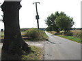
View south along Buckenham Road
The road links the villages of Lingwood and Strumpshaw.
Image: © Evelyn Simak
Taken: 20 Sep 2009
0.18 miles
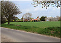
5
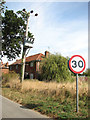
Transformer supplying cottages in Buckenham Road
Image: © Evelyn Simak
Taken: 20 Sep 2009
0.21 miles