IMAGES TAKEN NEAR TO
Waterlow, NORWICH, NR13 4LJ
Introduction
This page details the photographs taken nearby to Waterlow, NR13 4LJ by members of the Geograph project.
The Geograph project started in 2005 with the aim of publishing, organising and preserving representative images for every square kilometre of Great Britain, Ireland and the Isle of Man.

There are currently over 7.5m images from over14,400 individuals and you can help contribute to the project by visiting https://www.geograph.org.uk
Image Map
Images are licensed for reuse under creativecommons.org/licenses/by-sa/2.0
Notes
- Clicking on the map will re-center to the selected point.
- The higher the marker number, the further away the image location is from the centre of the postcode.
Image Listing (6 Images Found)
Images are licensed for reuse under creativecommons.org/licenses/by-sa/2.0
Image
Details
Distance
1
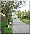
Hemblington Road past Waterlow
Approaching Yarmouth Road (A47).
Image: © Evelyn Simak
Taken: 28 Apr 2013
0.07 miles
5
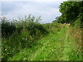
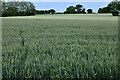
Bridle Path, Blofield
Years ago we used to ride this path. Very glad to see it's still there, and full of dragonflies and butterflies today.
Image: © Golda Conneely
Taken: 1 Aug 2005
0.24 miles
6

View towards Sparrow Hall
The Hall as such no longer exists. The premises have been taken over by a van hire business.
Image: © Evelyn Simak
Taken: 3 Jan 2013
0.24 miles