IMAGES TAKEN NEAR TO
Church Alley, NORWICH, NR13 4JJ
Introduction
This page details the photographs taken nearby to Church Alley, NR13 4JJ by members of the Geograph project.
The Geograph project started in 2005 with the aim of publishing, organising and preserving representative images for every square kilometre of Great Britain, Ireland and the Isle of Man.

There are currently over 7.5m images from over14,400 individuals and you can help contribute to the project by visiting https://www.geograph.org.uk
Image Map
Images are licensed for reuse under creativecommons.org/licenses/by-sa/2.0
Notes
- Clicking on the map will re-center to the selected point.
- The higher the marker number, the further away the image location is from the centre of the postcode.
Image Listing (71 Images Found)
Images are licensed for reuse under creativecommons.org/licenses/by-sa/2.0
Image
Details
Distance
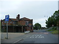
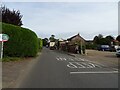
2
The Street, Blofield
At the junction with Garden Road
Image: © Geographer
Taken: 1 Jun 2013
0.02 miles
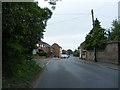
3
Doctors Road, Blofield
Taken from corner of Doctors Road and Yarmouth Road.
Image: © Martin Thirkettle
Taken: 31 Jan 2009
0.04 miles
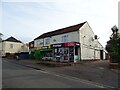
5
North Street, Blofield
At the junction with The Street & Doctors Road
Image: © Geographer
Taken: 1 Jun 2013
0.05 miles
6
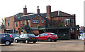
Kings Head Public House
Rear view of the Kings Head taken from car park looking south towards Yarmouth Road traffic light junction.
Image: © Martin Thirkettle
Taken: 31 Jan 2009
0.05 miles
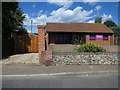
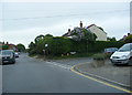
8
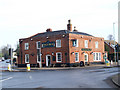
Kings Head PH on junction of Yarmouth Road and The Street
Image: © Martin Thirkettle
Taken: 31 Jan 2009
0.06 miles
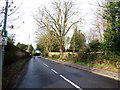
9

The Street, Blofield & Kings Head Public House
Approaching the junction with Yarmouth Road
Image: © Geographer
Taken: 1 Jun 2013
0.06 miles