IMAGES TAKEN NEAR TO
Stanley Trett Close, NR13 4FU
Introduction
This page details the photographs taken nearby to Stanley Trett Close, NR13 4FU by members of the Geograph project.
The Geograph project started in 2005 with the aim of publishing, organising and preserving representative images for every square kilometre of Great Britain, Ireland and the Isle of Man.

There are currently over 7.5m images from over14,400 individuals and you can help contribute to the project by visiting https://www.geograph.org.uk
Image Map
Images are licensed for reuse under creativecommons.org/licenses/by-sa/2.0
Notes
- Clicking on the map will re-center to the selected point.
- The higher the marker number, the further away the image location is from the centre of the postcode.
Image Listing (12 Images Found)
Images are licensed for reuse under creativecommons.org/licenses/by-sa/2.0
Image
Details
Distance
2
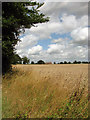
Ripe wheat
In field beside Holly Lane; the building seen in the distance is Holly Barn (in same grid square).
Image: © Evelyn Simak
Taken: 10 Aug 2008
0.08 miles
5
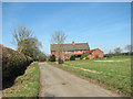
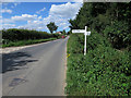
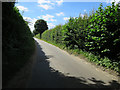
View along Holly Lane
Holly Barn can be seen in the background.
Image: © Evelyn Simak
Taken: 12 Mar 2015
0.10 miles
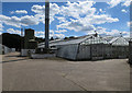
6
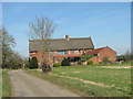
Barn conversion in Holly Lane
It is called Holly Barn.
Image: © Evelyn Simak
Taken: 12 Mar 2015
0.10 miles
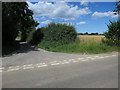
9
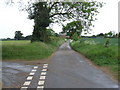
Looking Down Holly Lane to Holly Barn
Road to the left joins to Shack Lane.
Image: © Ian Robertson
Taken: 16 May 2007
0.18 miles