IMAGES TAKEN NEAR TO
Hall Road, NORWICH, NR13 4DE
Introduction
This page details the photographs taken nearby to Hall Road, NR13 4DE by members of the Geograph project.
The Geograph project started in 2005 with the aim of publishing, organising and preserving representative images for every square kilometre of Great Britain, Ireland and the Isle of Man.

There are currently over 7.5m images from over14,400 individuals and you can help contribute to the project by visiting https://www.geograph.org.uk
Image Map
Images are licensed for reuse under creativecommons.org/licenses/by-sa/2.0
Notes
- Clicking on the map will re-center to the selected point.
- The higher the marker number, the further away the image location is from the centre of the postcode.
Image Listing (16 Images Found)
Images are licensed for reuse under creativecommons.org/licenses/by-sa/2.0
Image
Details
Distance
1
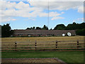
Home Farm
Converted vernacular farm building at Home Farm
Image: © P Gaskell
Taken: Unknown
0.04 miles
3
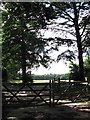
Padlocked gate
One of the entrances into the grounds of the former Blofield Hall, now converted into luxury country homes.
Image: © Evelyn Simak
Taken: 10 Aug 2008
0.16 miles
4
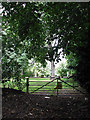
Padlocked gate with a warning
The sign affixed to this gate is broken but its message can still be figured out: http://www.geograph.org.uk/photo/917279 - not very often does one come across so many forbidding signs in so small an area.
Image: © Evelyn Simak
Taken: 10 Aug 2008
0.17 miles
5
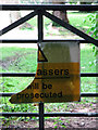
Broken sign
Affixed to a gate by School Road; the message warns that trespassers will be prosecuted. For a wider view see > http://www.geograph.org.uk/photo/917276. Not very often does one come across so many forbidding signs in so small an area.
Image: © Evelyn Simak
Taken: 10 Aug 2008
0.18 miles
6
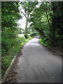
A dip in School Road
Where it is taken over a body of water > http://www.geograph.org.uk/photo/917290 - http://www.geograph.org.uk/photo/917295 on the approach to Blofield.
Image: © Evelyn Simak
Taken: 10 Aug 2008
0.20 miles
7
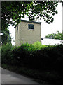
Coach House
The tower of the former Coach House on the grounds of Blofield Hall > http://www.geograph.org.uk/photo/917259 - peeking over the hedge growing alongside School Road.
Image: © Evelyn Simak
Taken: 10 Aug 2008
0.20 miles
8
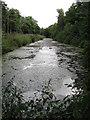
A stagnant body of water
On the opposite side of the road from > http://www.geograph.org.uk/photo/917290. The woodland is Horsey Wood.
Image: © Evelyn Simak
Taken: 10 Aug 2008
0.20 miles
9
Snellings, Blofield Corner
Electrical goods showroom.
Image: © Hugh Venables
Taken: 6 Aug 2016
0.20 miles
10
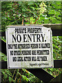
Only the Authorized Person is Allowed
See > http://www.geograph.org.uk/photo/917283 for a wider view; not very often does one come across so many forbidding signs in so small an area.
Image: © Evelyn Simak
Taken: 10 Aug 2008
0.21 miles