IMAGES TAKEN NEAR TO
Aldis Road, NORWICH, NR13 3BN
Introduction
This page details the photographs taken nearby to Aldis Road, NR13 3BN by members of the Geograph project.
The Geograph project started in 2005 with the aim of publishing, organising and preserving representative images for every square kilometre of Great Britain, Ireland and the Isle of Man.

There are currently over 7.5m images from over14,400 individuals and you can help contribute to the project by visiting https://www.geograph.org.uk
Image Map
Images are licensed for reuse under creativecommons.org/licenses/by-sa/2.0
Notes
- Clicking on the map will re-center to the selected point.
- The higher the marker number, the further away the image location is from the centre of the postcode.
Image Listing (79 Images Found)
Images are licensed for reuse under creativecommons.org/licenses/by-sa/2.0
Image
Details
Distance
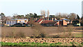
3
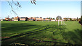
Acle Academy sports field
As seen across the sports field from Mill Lane. Opened as a secondary modern in 1959 and originally designed to provide accommodation for just 300 pupils, the school is currently known as Acle Academy, a mixed, comprehensive school for pupils between the ages of 11 and 16. In 1978, it became comprehensive as part of a reorganisation of education within the county, and in 1992 the school became grant-maintained and self-governing, adopting foundation status in 1999 with the change in national government. In September 2003, the school was awarded specialist status in science and mathematics and became Acle Specialist Science High School and most recently, in September 2012, changed its name to Acle Academy.
Image: © Evelyn Simak
Taken: 31 Dec 2015
0.09 miles
4
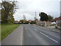
South Walsham Road, Acle
Looking south east.
Image: © JThomas
Taken: 25 Apr 2016
0.10 miles
9
View towards Acle Academy
As seen from the glade in Jubilee Wood > http://www.geograph.org.uk/photo/4779069. Opened as a secondary modern in 1959 and originally designed to provide accommodation for just 300 pupils, the school is currently known as Acle Academy, a mixed, comprehensive school for pupils between the ages of 11 and 16. In 1978, it became comprehensive as part of a reorganisation of education within the county, and in 1992 the school became grant-maintained and self-governing, adopting foundation status in 1999 with the change in national government. In September 2003, the school was awarded specialist status in science and mathematics and became Acle Specialist Science High School and most recently, in September 2012, changed its name to Acle Academy.
Image: © Evelyn Simak
Taken: 31 Dec 2015
0.15 miles
10
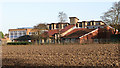
Acle Academy
As seen from the path to The Windle. Opened as a secondary modern in 1959 and originally designed to provide accommodation for just 300 pupils, the school is currently known as Acle Academy, a mixed, comprehensive school for pupils between the ages of 11 and 16. In 1978, it became comprehensive as part of a reorganisation of education within the county, and in 1992 the school became grant-maintained and self-governing, adopting foundation status in 1999 with the change in national government. In September 2003, the school was awarded specialist status in science and mathematics and became Acle Specialist Science High School and most recently, in September 2012, changed its name to Acle Academy.
Image: © Evelyn Simak
Taken: 31 Dec 2015
0.15 miles