IMAGES TAKEN NEAR TO
Mendham Close, NORWICH, NR1 2JU
Introduction
This page details the photographs taken nearby to Mendham Close, NR1 2JU by members of the Geograph project.
The Geograph project started in 2005 with the aim of publishing, organising and preserving representative images for every square kilometre of Great Britain, Ireland and the Isle of Man.

There are currently over 7.5m images from over14,400 individuals and you can help contribute to the project by visiting https://www.geograph.org.uk
Image Map
Images are licensed for reuse under creativecommons.org/licenses/by-sa/2.0
Notes
- Clicking on the map will re-center to the selected point.
- The higher the marker number, the further away the image location is from the centre of the postcode.
Image Listing (149 Images Found)
Images are licensed for reuse under creativecommons.org/licenses/by-sa/2.0
Image
Details
Distance
1
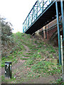
Steps leading up to Hall Road
From Lakenham Way, which follows the course of a section of the GER railway line and is now a public foot and cycle path.
Image: © Evelyn Simak
Taken: 28 Feb 2016
0.06 miles
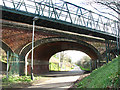
2
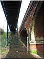
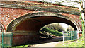
Road bridge and footbridge
The brick-built bridge (at right) carries Hall Road over Lakenham Way, which follows the course of a section of the GER railway line and is now a public foot and cycle path. The steel construction at left is a footbridge. For a wider view of both bridges see > http://www.geograph.org.uk/photo/4844394.
Image: © Evelyn Simak
Taken: 28 Feb 2016
0.06 miles
3

Brickwork on road bridge
The brick-built bridge carries Hall Road over Lakenham Way, which follows the course of a section of the GER railway line and is now a public foot and cycle path. For other views of this bridge see > http://www.geograph.org.uk/photo/4844394 and http://www.geograph.org.uk/photo/4844385.
Image: © Evelyn Simak
Taken: 28 Feb 2016
0.06 miles
4
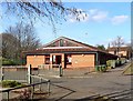
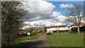
Norwich City Council Area Office, Mansfield Lane
This area council office is on Mansfield Lane, Lakenham. They had to knock down a whole row of local authority houses to build this!
Image: © Paul Shreeve
Taken: 27 Feb 2008
0.06 miles
5
Hall Road bridge over the Lakenham Way footpath
For a view of the bridge taken from the footpath see > https://www.geograph.org.uk/photo/4844394.
Image: © Evelyn Simak
Taken: 15 Aug 2019
0.06 miles
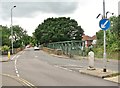
6
Path to Mansfield Lane
As seen from Lakenham Way which follows the course of a section of the GER railway line and is now a public foot and cycle path.
Image: © Evelyn Simak
Taken: 28 Feb 2016
0.06 miles
7
View south along Lakenham Way
The brick-built bridge carries Hall Road over Lakenham Way, which follows the course of a section of the GER railway line and is now a public foot and cycle path. The steel construction in the foreground is a footbridge.
Image: © Evelyn Simak
Taken: 28 Feb 2016
0.07 miles
8
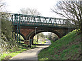
Hall Road crosses over Lakenham Way
The brick-built bridge carries Hall Road over Lakenham Way, which follows the course of a section of the GER railway line and is now a public foot and cycle path. The steel construction in the foreground is a footbridge.
Image: © Evelyn Simak
Taken: 28 Feb 2016
0.07 miles
9
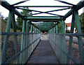
Footbridge over disused railway
Now the Lakenham Way Footpath.
Image: © JThomas
Taken: 25 Jul 2015
0.07 miles
10
Lakenham Way under Hall Road
The bridge carries Hall Road over Lakenham Way, which follows the course of a section of the GER railway line and is now a public foot and cycle path.
Image: © Evelyn Simak
Taken: 28 Feb 2016
0.07 miles