IMAGES TAKEN NEAR TO
Paper Mill Yard, NORWICH, NR1 2GG
Introduction
This page details the photographs taken nearby to Paper Mill Yard, NR1 2GG by members of the Geograph project.
The Geograph project started in 2005 with the aim of publishing, organising and preserving representative images for every square kilometre of Great Britain, Ireland and the Isle of Man.

There are currently over 7.5m images from over14,400 individuals and you can help contribute to the project by visiting https://www.geograph.org.uk
Image Map
Images are licensed for reuse under creativecommons.org/licenses/by-sa/2.0
Notes
- Clicking on the map will re-center to the selected point.
- The higher the marker number, the further away the image location is from the centre of the postcode.
Image Listing (790 Images Found)
Images are licensed for reuse under creativecommons.org/licenses/by-sa/2.0
Image
Details
Distance
1
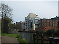
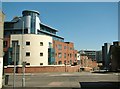
3 different ages
The Norman defences with the industrial past then the city living, flat building 21st Century
Image: © Ashley Dace
Taken: 23 Apr 2009
0.01 miles
2
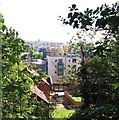
View to Carrow from The Wilderness
The Wilderness is an area north of Carrow Hill and which used to be a pleasure garden in the 18th and 19th centuries. It is now a protected woodland designated a publicly accessible recrational open space.
Image: © Evelyn Simak
Taken: 6 May 2018
0.01 miles
3
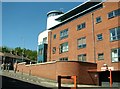
The Blue Mill
This building formed part of the Carrow Works owned by the Colman family of mustard fame and is situated in Paper Mill Yard where all the old industrial buildings have since been converted into flats.
Jeremiah Colman had started his mustard and flour business in 1814 at Stoke Holy Cross. It was his great-nephew Jeremiah James Colman who in 1850 bought land from Norfolk Railway at Carrow, and in 1858 brought the company to Carrow and established the Carrow Works which by 1869 had 1100 employees. Colman’s won a special place in the heart of workers in the city, because the company looked after its employees, who enjoyed better conditions than in many other city factories.
Image: © Evelyn Simak
Taken: 6 May 2018
0.02 miles
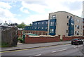
4
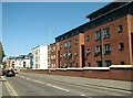
King Street past flats at the Blue Mill
For another view of the Blue Mill see > http://www.geograph.org.uk/photo/5766230.
Image: © Evelyn Simak
Taken: 6 May 2018
0.02 miles
5
Blue Mill
By the entrance to Paper Mill Yard off King Street. This building formed part of the Carrow Works owned by the Colman family of mustard fame and is situated in Paper Mill Yard where all the old industrial buildings have since been converted into flats.
Jeremiah Colman had started his mustard and flour business in 1814 at Stoke Holy Cross. It was his great-nephew Jeremiah James Colman who in 1850 bought land from Norfolk Railway at Carrow, and in 1858 brought the company to Carrow and established the Carrow Works which by 1869 had 1100 employees. Colman’s won a special place in the heart of workers in the city, because the company looked after its employees, who enjoyed better conditions than in many other city factories.
Image: © Evelyn Simak
Taken: 6 May 2018
0.02 miles
6
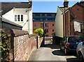
Cyclist on King Street
This view was taken from Winkles Row.
Image: © Evelyn Simak
Taken: 6 May 2018
0.03 miles
7
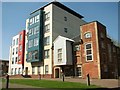
Granary View / Paper Mill Yard
The block of flats immediately adjoins one of the old industrial buildings (now also converted into housing and called Granary View) on the Carrow Works' paper mill yard. Jeremiah Colman had started his mustard and flour business in 1814 at Stoke Holy Cross. It was, however, his great-nephew Jeremiah James Colman who in 1850 bought land from Norfolk Railway at Carrow, and in 1858 brought the company to Carrow and established the Carrow Works which by 1869 had 1100 employees. Colman’s won a special place in the heart of workers in the city, because the company looked after its employees, who enjoyed better conditions than in many other city factories. Many of the old Carrow Works buildings have since been converted into housing. See also > https://www.geograph.org.uk/photo/5766204 and http://www.geograph.org.uk/photo/5766213.
Image: © Evelyn Simak
Taken: 8 May 2018
0.03 miles
9
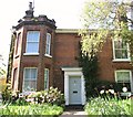
House at 280 King Street
This house, which is the first in the terrace called Prospect Place, was once the Golden Lion Public House, with the first licensee, in 1839, having been Francis Puxley. The pub's last licensee, in 1904, was John Hipkin and the licence was dropped in 1907 after Colmans had acquired the property.
Image: © Evelyn Simak
Taken: 6 May 2018
0.03 miles
10
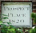
Date stone at Prospect Place
Prospect Place is a terrace of cottages > https://www.geograph.org.uk/photo/5766255 in King Street.
Image: © Evelyn Simak
Taken: 6 May 2018
0.03 miles