IMAGES TAKEN NEAR TO
Stuart Road, NORWICH, NR1 2BY
Introduction
This page details the photographs taken nearby to Stuart Road, NR1 2BY by members of the Geograph project.
The Geograph project started in 2005 with the aim of publishing, organising and preserving representative images for every square kilometre of Great Britain, Ireland and the Isle of Man.

There are currently over 7.5m images from over14,400 individuals and you can help contribute to the project by visiting https://www.geograph.org.uk
Image Map
Images are licensed for reuse under creativecommons.org/licenses/by-sa/2.0
Notes
- Clicking on the map will re-center to the selected point.
- The higher the marker number, the further away the image location is from the centre of the postcode.
Image Listing (1105 Images Found)
Images are licensed for reuse under creativecommons.org/licenses/by-sa/2.0
Image
Details
Distance
1
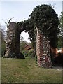
St Peter's Southgate, Norwich
The ruins of the church of St Peter's Southgate. The ruins are now located within a small park.
Image: © David Robertson
Taken: 22 Apr 2007
0.00 miles
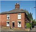
2
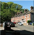
Terraced cottages in Stuart Road (Carrow)
The terraced cottages situated in this short cul-de-sac off King Street are almost built into the bank of and overshadowed by a wooded ridge which is part of an area known as the Wilderness, adjacent to Carrow Hill.
Image: © Evelyn Simak
Taken: 6 May 2018
0.00 miles
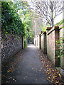
3

Houses in Southgate Lane, Norwich
For some reason all windows facing Southgate Lane have been blocked.
Image: © Evelyn Simak
Taken: 7 Oct 2010
0.01 miles
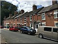
6
Terrace by the corner of Stuart Road (Carrow) and King Street
Image: © Evelyn Simak
Taken: 6 May 2018
0.01 miles
7
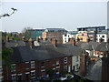
Old and new housing
It's amazing how housing has changed over the past 100 years.
Image: © Ashley Dace
Taken: 23 Apr 2009
0.02 miles
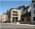
8
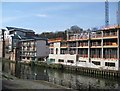
Waterfront development
Development continues along the Wensum next to Novi Sad footbridge.
Image: © Lis Burke
Taken: 22 Apr 2008
0.02 miles
9
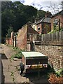
Between Alan Road & Stuart Road
A few of the original outside loo blocks remain.
Image: © Fernweh
Taken: 29 Jul 2020
0.02 miles
10
Half Moon Yard in King Street
A modern block of flats comprising 33 apartments, named after the Half Moon public house which once stood here. The converted Albion Mill building (Read's Flour Mill) can be seen in the background.
Image: © Evelyn Simak
Taken: 6 May 2018
0.02 miles