IMAGES TAKEN NEAR TO
Burley Road, NORWICH, NR12 8HH
Introduction
This page details the photographs taken nearby to Burley Road, NR12 8HH by members of the Geograph project.
The Geograph project started in 2005 with the aim of publishing, organising and preserving representative images for every square kilometre of Great Britain, Ireland and the Isle of Man.

There are currently over 7.5m images from over14,400 individuals and you can help contribute to the project by visiting https://www.geograph.org.uk
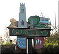
Image Map
Images are licensed for reuse under creativecommons.org/licenses/by-sa/2.0
Notes
- Clicking on the map will re-center to the selected point.
- The higher the marker number, the further away the image location is from the centre of the postcode.
Image Listing (51 Images Found)
Images are licensed for reuse under creativecommons.org/licenses/by-sa/2.0
Image
Details
Distance
1
Village sign - detail
The village sign is located beside Burley Road, diagonally across from the Primitive Methodist chapel > http://www.geograph.org.uk/photo/1047229. For a wider view of the village sign see > http://www.geograph.org.uk/photo/1047232.
Image: © Evelyn Simak
Taken: 15 Nov 2008
0.04 miles
2
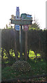
Village sign
The village sign is located beside Burley Road, diagonally across from the Primitive Methodist chapel > http://www.geograph.org.uk/photo/1047229. See > http://www.geograph.org.uk/photo/1047237 for a more detailed view.
Image: © Evelyn Simak
Taken: 15 Nov 2008
0.04 miles
3
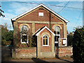
Primitive Methodist Chapel
On Burley Road. The date stone on the gable end gives the year of its construction as 1869. See also > http://www.geograph.org.uk/photo/1047229.
Image: © Evelyn Simak
Taken: 15 Nov 2008
0.05 miles
4
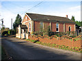
Primitive Methodist Chapel
On Burley Road. The date stone on the gable end gives the year of its construction as 1869. See also > http://www.geograph.org.uk/photo/1047230.
Image: © Evelyn Simak
Taken: 15 Nov 2008
0.05 miles
5
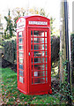
Red telephone box
This old red telephone box is located beside Burley Road, diagonally across the road from the Primitive Methodist chapel > http://www.geograph.org.uk/photo/1047229 where it stands in a row with a EII postbox, the village sign and the village noticeboard. See > http://www.geograph.org.uk/photo/1047249 for a wider view of the location.
Image: © Evelyn Simak
Taken: 15 Nov 2008
0.05 miles
6
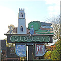
Sloley village sign
The name of the village comes from the Sloe or blackthorn bushes which used to be in abundance in earlier times. The sign has four elements. The church of St. Bartholomew flanked on the left by a wheatsheaf in a stubble field reflecting the agricultural heritage of the parish and some of those sloe bushes on the other.
The figure enjoying a glass of sloe gin perhaps, represents Ralph de Beaufour who was Tenant-in-Chief of much of the area in 1086. The reference to Domesday gives the old name of the village, Slaleia. The other shield with the three knives is the symbol of St Bartholomew who was flayed or skinned alive. https://www.geograph.org.uk/photo/6674186
Image: © Adrian S Pye
Taken: 12 Nov 2020
0.06 miles
7
Sloley village sign and Frankfort street
The name of the village comes from the Sloe or blackthorn bushes which used to be in abundance in earlier times. The sign has four elements. The church of St. Bartholomew flanked on the left by a wheatsheaf in a stubble field reflecting the agricultural heritage of the parish and some of those sloe bushes on the other.
The figure enjoying a glass of sloe gin perhaps, represents Ralph de Beaufour who was Tenant-in-Chief of much of the area in 1086. The reference to Domesday gives the old name of the village, Slaleia. The other shield with the three knives is the symbol of St Bartholomew who was flayed or skinned alive. https://www.geograph.org.uk/photo/6674178
Image: © Adrian S Pye
Taken: 12 Nov 2020
0.06 miles
8
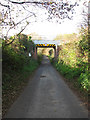
Bridge 377
Carrying the railway line over the road, just west of Frankfort. See > http://www.geograph.org.uk/photo/1047259 for a close-up of the bridge's number plate.
Image: © Evelyn Simak
Taken: 15 Nov 2008
0.07 miles
9
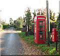
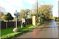
Burley Road
Next to each other on a small green diagonally across the road from the Primitive Methodist chapel > http://www.geograph.org.uk/photo/1047229 there are a postbox (EII), an old red telephone kiosk > http://www.geograph.org.uk/photo/1047241 - the village notice board and the village sign > http://www.geograph.org.uk/photo/1047237 all nicely lined up.
Image: © Evelyn Simak
Taken: 15 Nov 2008
0.07 miles
10
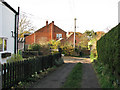
Here the bridleway ends
The public bridleway > http://www.geograph.org.uk/photo/1046356 turns into an unsurfaced lane linking with Burley Road, the main thoroughfare. The public bridleway turns off Roman Road, leading past horse pastures which adjoin on both sides > http://www.geograph.org.uk/photo/1046368. It emerges here, in Frankfort, a short distance further to the north.
Image: © Evelyn Simak
Taken: 15 Nov 2008
0.07 miles