IMAGES TAKEN NEAR TO
North Walsham Road, NORWICH, NR12 7JB
Introduction
This page details the photographs taken nearby to North Walsham Road, NR12 7JB by members of the Geograph project.
The Geograph project started in 2005 with the aim of publishing, organising and preserving representative images for every square kilometre of Great Britain, Ireland and the Isle of Man.

There are currently over 7.5m images from over14,400 individuals and you can help contribute to the project by visiting https://www.geograph.org.uk
Image Map
Images are licensed for reuse under creativecommons.org/licenses/by-sa/2.0
Notes
- Clicking on the map will re-center to the selected point.
- The higher the marker number, the further away the image location is from the centre of the postcode.
Image Listing (73 Images Found)
Images are licensed for reuse under creativecommons.org/licenses/by-sa/2.0
Image
Details
Distance
3
Electricity Substation
An essential part of the community for our modern lifestyles.
Image: © Alison Rawson
Taken: 31 Aug 2007
0.05 miles
4
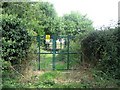
Path to Common Farm
This public footpath links North Walsham Road with Common Farm, further to the west > http://www.geograph.org.uk/photo/1169462.
Image: © Evelyn Simak
Taken: 19 Feb 2009
0.06 miles
5
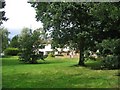
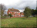
Village green?
This piece of vacant land cushions these houses from the adjacent housing estate.
Image: © Alison Rawson
Taken: 31 Aug 2007
0.06 miles
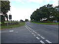
7
Potspoon Hole meets North Walsham Road
Image: © Evelyn Simak
Taken: 19 Feb 2009
0.08 miles
8
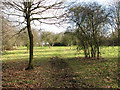
Path through Ling Common
This public footpath, turning off North Walsham Road > http://www.geograph.org.uk/photo/1169487 and leading to Common Farm > http://www.geograph.org.uk/photo/1169462 further to the west, is also used by riders as is evidenced by the imprints of horses' hooves in the damp soil.
Image: © Evelyn Simak
Taken: 19 Feb 2009
0.08 miles
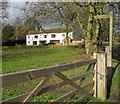
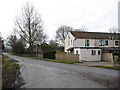
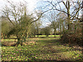
9
House at Ling Common
This view was taken from the public footpath through Ling Common, which links North Walsham Road > http://www.geograph.org.uk/photo/1169487 with Common Farm further to the west.
Image: © Evelyn Simak
Taken: 19 Feb 2009
0.08 miles
10
Ling Common
This public footpath links Common Farm, further to the west, with North Walsham Road > http://www.geograph.org.uk/photo/1169487. Here it traverses Ling Common.
Image: © Evelyn Simak
Taken: 19 Feb 2009
0.09 miles