
IMAGES TAKEN NEAR TO
Rectory Road, NORWICH, NR12 7HR
Introduction
This page details the photographs taken nearby to Rectory Road, NR12 7HR by members of the Geograph project.
The Geograph project started in 2005 with the aim of publishing, organising and preserving representative images for every square kilometre of Great Britain, Ireland and the Isle of Man.

There are currently over 7.5m images from over14,400 individuals and you can help contribute to the project by visiting https://www.geograph.org.uk
Image Map
Images are licensed for reuse under creativecommons.org/licenses/by-sa/2.0
Notes
- Clicking on the map will re-center to the selected point.
- The higher the marker number, the further away the image location is from the centre of the postcode.
Image Listing (72 Images Found)
Images are licensed for reuse under creativecommons.org/licenses/by-sa/2.0
Image
Details
Distance
1

New road layout ahead
The road is now one-way from here across the ex-railway bridge which now carries the road over the Bure Walks
Image: © Adrian S Pye
Taken: 23 Dec 2014
0.01 miles
2

Rectory Road looking to the bridge over the Bure Valley Railway
Image: © Helen Steed
Taken: 2 Nov 2012
0.02 miles
3

Railway bridge No 1297 - view through the arch
This bridge takes Rectory Road over the Bure Valley Railway and walk. For a wider view see > http://www.geograph.org.uk/photo/1279160. See also > http://www.geograph.org.uk/photo/1170322.
The Bure Valley Railway is Norfolk's longest fifteen inch gauge line. It opened on 10. July 1990, and the long distance footpath running parallel with it was opened in 1991. The Bure Valley Railway runs between Aylsham and Wroxham, with stations in Brampton, Buxton and Coltishall. The railway operates services using either Steam or Diesel locomotives - ten buckets of coal are required for fuelling a steam locomotive on its 18 mile round trip > Image http://www.bvrw.co.uk/
The railway runs on the trackbed of the East Norfolk Railway (ENR), opened in 1877 with the first section connecting Norwich and Cromer, and an extension from Wroxham to Aylsham in 1880. The line was taken over by the Great Eastern Railway in 1882 and amalgamated into the London & North Eastern Railway in 1923. Passenger service stopped in 1952 but freight service continued until the 1970s. Coal traffic was carried from Norwich Thorpe via Aylsham to Norwich City and concrete building components were carried from Lenwade. This traffic ended in 1981 and the line through Aylsham formally closed on 6 January 1982.
Image: © Evelyn Simak
Taken: 30 Apr 2009
0.03 miles
4

Bridge number 1297
This bridge takes Rectory Road over the Bure Valley Railway. For a wider view of the location see > http://www.geograph.org.uk/photo/1170322.
Image: © Evelyn Simak
Taken: 19 Feb 2009
0.03 miles
5

Bridge over Bure Valley Railway
Bridge number 1297 takes Rectory Road over the Bure Valley Railway. This view was taken in northerly direction.
Image: © Evelyn Simak
Taken: 19 Feb 2009
0.03 miles
6
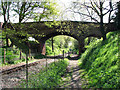
Railway bridge No 1297
This bridge takes Rectory Road over the Bure Valley Railway and walk. See also > http://www.geograph.org.uk/photo/1170322.
The Bure Valley Railway is Norfolk's longest fifteen inch gauge line. It opened on 10. July 1990, and the long distance footpath running parallel with it was opened in 1991. The Bure Valley Railway runs between Aylsham and Wroxham, with stations in Brampton, Buxton and Coltishall. The railway operates services using either Steam or Diesel locomotives - ten buckets of coal are required for fuelling a steam locomotive on its 18 mile round trip > Image http://www.bvrw.co.uk/
The railway runs on the trackbed of the East Norfolk Railway (ENR), opened in 1877 with the first section connecting Norwich and Cromer, and an extension from Wroxham to Aylsham in 1880. The line was taken over by the Great Eastern Railway in 1882 and amalgamated into the London & North Eastern Railway in 1923. Passenger service stopped in 1952 but freight service continued until the 1970s. Coal traffic was carried from Norwich Thorpe via Aylsham to Norwich City and concrete building components were carried from Lenwade. This traffic ended in 1981 and the line through Aylsham formally closed on 6 January 1982.
Image: © Evelyn Simak
Taken: 30 Apr 2009
0.04 miles
7

Bridge over the Bure Valley Railway
This bridge carries Rectory Road, Coltishall, over the Bure Valley Railway and the Bure Valley Path.
Image: © Glen Denny
Taken: 28 May 2011
0.04 miles
8

Railway Bridges No 1297 and 1298
Bridge no 1297 (in foreground) takes Rectory Road over the Bure Valley Railway and walk. Bridge no 1298 (seen in background, in adjacent grid square) takes the B1150 (Station Road) over the railway line.
The Bure Valley Railway is Norfolk's longest fifteen inch gauge line. It opened on 10. July 1990, and the long distance footpath running parallel with it was opened in 1991. The Bure Valley Railway runs between Aylsham and Wroxham, with stations in Brampton, Buxton and Coltishall. The railway operates services using either Steam or Diesel locomotives - ten buckets of coal are required for fuelling a steam locomotive on its 18 mile round trip > Image http://www.bvrw.co.uk/
The railway runs on the trackbed of the East Norfolk Railway (ENR), opened in 1877 with the first section connecting Norwich and Cromer, and an extension from Wroxham to Aylsham in 1880. The line was taken over by the Great Eastern Railway in 1882 and amalgamated into the London & North Eastern Railway in 1923. Passenger service stopped in 1952 but freight service continued until the 1970s. Coal traffic was carried from Norwich Thorpe via Aylsham to Norwich City and concrete building components were carried from Lenwade. This traffic ended in 1981 and the line through Aylsham formally closed on 6 January 1982.
Image: © Evelyn Simak
Taken: 30 Apr 2009
0.04 miles
9

House beside railway line
This view was taken from bridge 1297 / Rectory Road > http://www.geograph.org.uk/photo/1170322.
Image: © Evelyn Simak
Taken: 19 Feb 2009
0.05 miles
10

Railway bridge No 1297
This bridge takes Rectory Road over the Bure Valley Railway and walk. For a view taken from the opposite direction see > http://www.geograph.org.uk/photo/1279160. See also > http://www.geograph.org.uk/photo/1170322.
The Bure Valley Railway is Norfolk's longest fifteen inch gauge line. It opened on 10. July 1990, and the long distance footpath running parallel with it was opened in 1991. The Bure Valley Railway runs between Aylsham and Wroxham, with stations in Brampton, Buxton and Coltishall. The railway operates services using either Steam or Diesel locomotives - ten buckets of coal are required for fuelling a steam locomotive on its 18 mile round trip > Image http://www.bvrw.co.uk/
The railway runs on the trackbed of the East Norfolk Railway (ENR), opened in 1877 with the first section connecting Norwich and Cromer, and an extension from Wroxham to Aylsham in 1880. The line was taken over by the Great Eastern Railway in 1882 and amalgamated into the London & North Eastern Railway in 1923. Passenger service stopped in 1952 but freight service continued until the 1970s. Coal traffic was carried from Norwich Thorpe via Aylsham to Norwich City and concrete building components were carried from Lenwade. This traffic ended in 1981 and the line through Aylsham formally closed on 6 January 1982.
Image: © Evelyn Simak
Taken: 30 Apr 2009
0.05 miles