IMAGES TAKEN NEAR TO
Walcott Green, NORWICH, NR12 0NS
Introduction
This page details the photographs taken nearby to Walcott Green, NR12 0NS by members of the Geograph project.
The Geograph project started in 2005 with the aim of publishing, organising and preserving representative images for every square kilometre of Great Britain, Ireland and the Isle of Man.

There are currently over 7.5m images from over14,400 individuals and you can help contribute to the project by visiting https://www.geograph.org.uk
Image Map
Images are licensed for reuse under creativecommons.org/licenses/by-sa/2.0
Notes
- Clicking on the map will re-center to the selected point.
- The higher the marker number, the further away the image location is from the centre of the postcode.
Image Listing (14 Images Found)
Images are licensed for reuse under creativecommons.org/licenses/by-sa/2.0
Image
Details
Distance
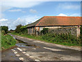
2
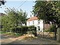
Walcott Hall, Walcott
For more information see here http://www.geograph.org.uk/photo/566870
Image: © Adrian S Pye
Taken: 25 Jul 2018
0.11 miles
3
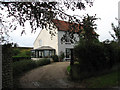
Walcott Hall
Originally there were two Halls in Walcott, East Hall and West Hall. The earliest mention of the Walcott family in northeast Norfolk is in East Hall. William de Edgefield's (1154 to 1189) mother, Maud de Walcott, granted two parts of the tithe of her lands in Walcott to the monks of Broomholm Priory > Image in Bacton. In 1240 and possibly 1281, Thomas de Walcott held part of the advowson (income) of Walcott church > Image and was lord of West Hall. The house depicted above appears to be the farmhouse.
For more information on the Walcott family see http://archive.is/dNlqR#selection-191.0-191.32
Image: © Evelyn Simak
Taken: 26 Sep 2007
0.11 miles
4
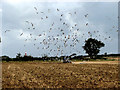
Following the plough
A large flock of seagulls, patiently waiting for tasty morsels to be unearthed by the ploughing activity. The top of Happisburgh lighthouse can just be seen above the hedgerow in the background.
Image: © Evelyn Simak
Taken: 26 Sep 2007
0.13 miles
5
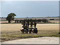
Getting ready for the ploughing
The view is across stubble in southeasterly direction.
Image: © Evelyn Simak
Taken: 26 Sep 2007
0.14 miles
8
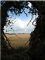
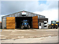
View east across stubble
The Happisburgh lighthouse can be glimpsed in the far distance.
Image: © Evelyn Simak
Taken: 26 Sep 2007
0.20 miles