IMAGES TAKEN NEAR TO
Pollard Street, NORWICH, NR12 0LB
Introduction
This page details the photographs taken nearby to Pollard Street, NR12 0LB by members of the Geograph project.
The Geograph project started in 2005 with the aim of publishing, organising and preserving representative images for every square kilometre of Great Britain, Ireland and the Isle of Man.

There are currently over 7.5m images from over14,400 individuals and you can help contribute to the project by visiting https://www.geograph.org.uk
Image Map
Images are licensed for reuse under creativecommons.org/licenses/by-sa/2.0
Notes
- Clicking on the map will re-center to the selected point.
- The higher the marker number, the further away the image location is from the centre of the postcode.
Image Listing (18 Images Found)
Images are licensed for reuse under creativecommons.org/licenses/by-sa/2.0
Image
Details
Distance
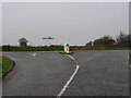
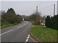
4
Sandy Lane junction
With North Walsham Road. See also > http://www.geograph.org.uk/photo/785692
Image: © Evelyn Simak
Taken: 2 May 2008
0.05 miles
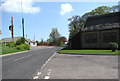
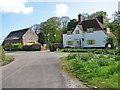
8
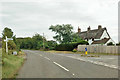
Cottages at junction
North Walsham Road towards Bacton bends left, to the right is Well Street.
Image: © Robin Webster
Taken: 12 Aug 2018
0.10 miles
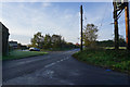
9
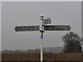
Signpost on C636 with cycleway information
Image: © David Pashley
Taken: 12 Dec 2020
0.11 miles