IMAGES TAKEN NEAR TO
Stubb Road, NORWICH, NR12 0BN
Introduction
This page details the photographs taken nearby to Stubb Road, NR12 0BN by members of the Geograph project.
The Geograph project started in 2005 with the aim of publishing, organising and preserving representative images for every square kilometre of Great Britain, Ireland and the Isle of Man.

There are currently over 7.5m images from over14,400 individuals and you can help contribute to the project by visiting https://www.geograph.org.uk
Image Map
Images are licensed for reuse under creativecommons.org/licenses/by-sa/2.0
Notes
- Clicking on the map will re-center to the selected point.
- The higher the marker number, the further away the image location is from the centre of the postcode.
Image Listing (9 Images Found)
Images are licensed for reuse under creativecommons.org/licenses/by-sa/2.0
Image
Details
Distance
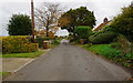
1
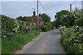
Stubb Road through Stubb
Access to Hickling Broad nature reserve.
Image: © Hugh Venables
Taken: 21 May 2023
0.02 miles
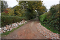
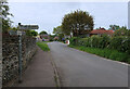
2
Houses at Stubb
This view was taken from the public footpath which starts at Ouse Lane and leads to the Hickling Broad Visitor Centre > http://www.geograph.org.uk/photo/1106786 further to the east.
Image: © Evelyn Simak
Taken: 7 Feb 2009
0.02 miles
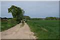
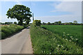
7
Stubb Road junction, Hickling Green
With a somewhat unhelpful "No access to Broads" sign pointing towards Hickling Broad nature reserve.
Image: © Hugh Venables
Taken: 21 May 2023
0.23 miles
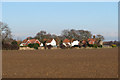
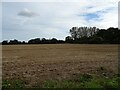
9
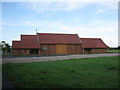
Hickling Barn
This newly completed village hall is now the centre for social events in Hickling.
Image: © don cload
Taken: 13 Jun 2012
0.24 miles