
IMAGES TAKEN NEAR TO
Regent Street, NORWICH, NR11 7NE
Introduction
This page details the photographs taken nearby to Regent Street, NR11 7NE by members of the Geograph project.
The Geograph project started in 2005 with the aim of publishing, organising and preserving representative images for every square kilometre of Great Britain, Ireland and the Isle of Man.

There are currently over 7.5m images from over14,400 individuals and you can help contribute to the project by visiting https://www.geograph.org.uk
Image Map
Images are licensed for reuse under creativecommons.org/licenses/by-sa/2.0
Notes
- Clicking on the map will re-center to the selected point.
- The higher the marker number, the further away the image location is from the centre of the postcode.
Image Listing (29 Images Found)
Images are licensed for reuse under creativecommons.org/licenses/by-sa/2.0
Image
Details
Distance
1
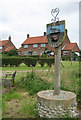
Wickmere/Wolterton Village Sign with "council houses"
This sign appears to serve two villages 2 km. apart - see Image for Wolterton. I have called the housing behind "council houses" but of course these days who knows if they have been bought by tenants, transferred to a housing association or what?
Image: © Zorba the Geek
Taken: 26 Jul 2007
0.01 miles
2

Wickmere with Wolterton village sign
The sign shows Wickmere church, Wolterton has only a derelict tower set in parkland. The cows represent the livestock farming while the tractor represent the food production side of Agriculture. The jester’s head, I cannot explain, perhaps it’s someone being funny! https://www.geograph.org.uk/photo/6689328
Image: © Adrian S Pye
Taken: 26 Nov 2020
0.02 miles
3

Wickmere with Wolterton village sign
The sign shows Wickmere church, Wolterton has only a derelict tower set in parkland. The cows represent the livestock farming while the tractor represent the food production side of Agriculture. The jester’s head, I cannot explain, perhaps it’s someone being funny! https://www.geograph.org.uk/photo/6689331
Image: © Adrian S Pye
Taken: 26 Nov 2020
0.03 miles
4

Wickmere village street with telephone kiosk
It's good to see an old-style telephone box surviving. Perhaps someone had the forethought to slap a preservation order on it?
Image: © Zorba the Geek
Taken: 26 Jul 2007
0.03 miles

6

Footpath across fields
This path leads in northwesterly direction past a disused airfield and to Lower Street beyond. A passer-by has deposited a pheasant's feather in a crack at the top of the public footpath sign.
Image: © Evelyn Simak
Taken: 28 Apr 2008
0.07 miles
7

Primitive Methodist Chapel
This Primitive Methodist Chapel is located at the corner of Regent Street and an unnamed road; the plaque above its door > http://www.geograph.org.uk/photo/780784 is inscribed 'Primitive Methodist Chapel 1897', indicating the year the chapel was built. Presently it is unused.
Image: © Evelyn Simak
Taken: 28 Apr 2008
0.08 miles
8

Primitive Methodist Chapel - detail
The gable end of a Primitive Methodist Chapel > http://www.geograph.org.uk/photo/780769, located at the corner of Regent Street and an unnamed road; a plaque above its door is inscribed ' Primitive Methodist Chapel 1897', indicating the year the chapel was built. Presently it is unused.
Image: © Evelyn Simak
Taken: 28 Apr 2008
0.08 miles
9

Primitive Methodist Chapel, Wickmere
This chapel is in a semi-derelict state and in other places would have been sold long ago for conversion.
Image: © Zorba the Geek
Taken: 26 Jul 2007
0.09 miles
10

Primitive Methodist Chapel - detail
Doorway and plaque above Primitive Methodist Chapel > http://www.geograph.org.uk/photo/780769, located at the corner of Regent Street and an unnamed road; the plaque is inscribed ' Primitive Methodist Chapel 1897', indicating the year the chapel was built. Presently it is unused.
Image: © Evelyn Simak
Taken: 28 Apr 2008
0.09 miles