IMAGES TAKEN NEAR TO
Wade Close, NORWICH, NR11 6LA
Introduction
This page details the photographs taken nearby to Wade Close, NR11 6LA by members of the Geograph project.
The Geograph project started in 2005 with the aim of publishing, organising and preserving representative images for every square kilometre of Great Britain, Ireland and the Isle of Man.

There are currently over 7.5m images from over14,400 individuals and you can help contribute to the project by visiting https://www.geograph.org.uk
Image Map
Images are licensed for reuse under creativecommons.org/licenses/by-sa/2.0
Notes
- Clicking on the map will re-center to the selected point.
- The higher the marker number, the further away the image location is from the centre of the postcode.
Image Listing (69 Images Found)
Images are licensed for reuse under creativecommons.org/licenses/by-sa/2.0
Image
Details
Distance
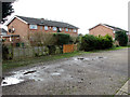
2
Garages at the back of houses in Wade Close
Image: © Evelyn Simak
Taken: 26 Feb 2017
0.01 miles
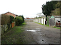
3
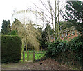
Allotments adjoining Aylsham Cemetery
The houses in the background are situated in Hungate Street.
Located on the west side of Norwich Road, Aylsham Cemetery is a traditional Victorian burial ground lined by yew trees at the entrance. The more recent burials are located at the rear of the site, which is bounded by allotments and council houses in the south-west.
Image: © Evelyn Simak
Taken: 26 Feb 2017
0.04 miles
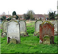
4
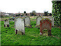
Graves in Aylsham Cemetery
The stone in the foreground marks the grave of Alfred Charles Woolsey, who died in 1882.
Located on the west side of Norwich Road, Aylsham Cemetery is a traditional Victorian burial ground lined by yew trees at the entrance. The more recent burials are located at the rear of the site, which is bounded by allotments and council houses in the south-west.
Image: © Evelyn Simak
Taken: 26 Feb 2017
0.04 miles
5
Allotments adjoining Aylsham Cemetery
The houses in the background are situated in Hungate Street.
Located on the west side of Norwich Road, Aylsham Cemetery is a traditional Victorian burial ground lined by yew trees at the entrance. The more recent burials are located at the rear of the site, which is bounded by allotments and council houses in the south-west.
Image: © Evelyn Simak
Taken: 26 Feb 2017
0.05 miles
6
Allotments west of Aylsham Cemetery
The houses in the background are situated in Hungate Street.
Located on the west side of Norwich Road, Aylsham Cemetery is a traditional Victorian burial ground lined by yew trees at the entrance. The more recent burials are located at the rear of the site, which is bounded by allotments and council houses in the south-west.
Image: © Evelyn Simak
Taken: 26 Feb 2017
0.05 miles
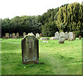
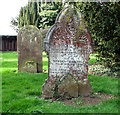
7
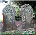
Gravestones in Aylsham Cemetery
The stones mark the graves of two couples, both named Philip and Mathilda Palmer.
Located on the west side of Norwich Road, Aylsham Cemetery is a traditional Victorian burial ground lined by yew trees at the entrance. The more recent burials are located at the rear of the site, which is bounded by allotments and council houses in the south-west.
Image: © Evelyn Simak
Taken: 26 Feb 2017
0.05 miles
9
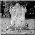
Unusual gravestone in Aylsham Cemetery
It dates from 1894 and marks the grave of Maria and Charles Wade. Located on the west side of Norwich Road, Aylsham Cemetery is a traditional Victorian burial ground lined by yew trees at the entrance. The more recent burials are located at the rear of the site, which is bounded by allotments and council houses in the south-west.
Image: © Evelyn Simak
Taken: 26 Feb 2017
0.05 miles
10
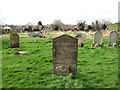
Gravestones in Aylsham Cemetery
The stone in the foreground marks the grave of Elizabeth Maria Thirkettle, who died in 1915, and of her parents, Joseph and Julia Anna Thirkettle (both died in 1916). Located on the west side of Norwich Road, Aylsham Cemetery is a traditional Victorian burial ground lined by yew trees at the entrance. The more recent burials are located at the rear of the site, which is bounded by allotments and council houses in the south-west.
Image: © Evelyn Simak
Taken: 26 Feb 2017
0.05 miles