IMAGES TAKEN NEAR TO
Sandy Lane, NORWICH, NR11 6DB
Introduction
This page details the photographs taken nearby to Sandy Lane, NR11 6DB by members of the Geograph project.
The Geograph project started in 2005 with the aim of publishing, organising and preserving representative images for every square kilometre of Great Britain, Ireland and the Isle of Man.

There are currently over 7.5m images from over14,400 individuals and you can help contribute to the project by visiting https://www.geograph.org.uk
Image Map
Images are licensed for reuse under creativecommons.org/licenses/by-sa/2.0
Notes
- Clicking on the map will re-center to the selected point.
- The higher the marker number, the further away the image location is from the centre of the postcode.
Image Listing (217 Images Found)
Images are licensed for reuse under creativecommons.org/licenses/by-sa/2.0
Image
Details
Distance
1
A Horse Chestnut Tree with Leaf Blotch
Leaf Blotch (Guinardia aesculi) is a fungus, which causes large chestnut-red or dull brown, irregular blotches to be seen on the leaves, from mid summer. These are often concentrated at the tips and margins of the leaves, and are often outlined by a conspicuous yellow band. Severely browned leaves are rolled upwards longitudinally, and whole leaves fall prematurely.
For more information see http://www.colnestour.org/news07/chestnuts.html
Image: © Evelyn Simak
Taken: 2 Sep 2007
0.05 miles
2
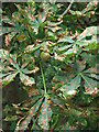
A Horse Chestnut Tree with Leaf Blotch - detail
Leaf Blotch (Guinardia aesculi) is a fungus, which causes large chestnut-red or dull brown, irregular blotches to be seen on the leaves, from mid summer. These are often concentrated at the tips and margins of the leaves, and are often outlined by a conspicuous yellow band. Severely browned leaves are rolled upwards longitudinally, and whole leaves fall prematurely.
For more information see http://www.colnestour.org/news07/chestnuts.html
Image: © Evelyn Simak
Taken: 2 Sep 2007
0.06 miles
3
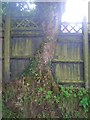
Tree / fence interface
Opposite St Michael's Primary School. The fence has actually been trimmed to accommodate the tree, it's not quite the "tree eats fence" story it first appears.
Image: © Gareth Hughes
Taken: Unknown
0.06 miles
5
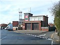
Fire Station, Cawston Road, Aylsham
Typical public service 'flat-roof' architecture of, perhaps, the 1960s.
Image: © Humphrey Bolton
Taken: 28 Oct 2008
0.11 miles
6
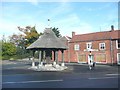
John Soame Memorial Pump, Cawston Road, Aylsham
See also Image, from which I have copied the following information:
After John Soame's death in 1911, a public well was given to the town by his uncle. The artesian well is 52 metres (170 ft) deep and its roof is thatched with Norfolk reed.
Image: © Humphrey Bolton
Taken: 28 Oct 2008
0.11 miles
7
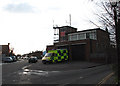
Fire and Ambulance Station
On Cawston Road
Image: © Evelyn Simak
Taken: 28 Nov 2007
0.12 miles
8
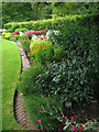
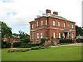
West Lodge - open garden
Herbaceous border. The grounds are not open to the public but on the occasion of an Open Garden charity event the public is given the opportunity to view the 9 acre gardens that surround this stately home.
A survey published by the Norfolk Gardens Trust in 1997 lists a number of sites of particular historic importance, one of these being West Lodge. The Georgian House with 17th century origins is surrounded by a nine acre garden with lawns, mature trees, a rose garden, herbaceous borders, an ornamental pond and a 19th century walled kitchen garden which is still being maintained as such.
Part of the property is located in the adjacent grid square to the east > http://www.geograph.org.uk/photo/882376 - http://www.geograph.org.uk/photo/882378 - http://www.geograph.org.uk/photo/882380 - http://www.geograph.org.uk/photo/882386 - http://www.geograph.org.uk/photo/882387 - http://www.geograph.org.uk/photo/882396
.
Image: © Evelyn Simak
Taken: 13 Jul 2008
0.12 miles
9
West Lodge - open garden
The lawn. The grounds are not open to the public but on the occasion of an Open Garden charity event the public is given the opportunity to view the 9 acre gardens that surround this stately home.
A survey published by the Norfolk Gardens Trust in 1997 lists a number of sites of particular historic importance, one of these being West Lodge. The Georgian House with 17th century origins is surrounded by a nine acre garden with lawns, mature trees, a rose garden, herbaceous borders, an ornamental pond and a 19th century walled kitchen garden which is still being maintained as such.
Part of the property is located in the adjacent grid square to the east > http://www.geograph.org.uk/photo/882376 - http://www.geograph.org.uk/photo/882378 - http://www.geograph.org.uk/photo/882380 - http://www.geograph.org.uk/photo/882386 - http://www.geograph.org.uk/photo/882387 - http://www.geograph.org.uk/photo/882396
.
Image: © Evelyn Simak
Taken: 13 Jul 2008
0.13 miles
10
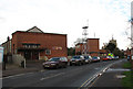
Youth Club on Cawston Road
Fire and Ambulance Station beyond > Image Part of the tower of St Michael's church can be seen in the background.
Image: © Evelyn Simak
Taken: 28 Nov 2007
0.13 miles