IMAGES TAKEN NEAR TO
Cromes Place, NORWICH, NR10 5JT
Introduction
This page details the photographs taken nearby to Cromes Place, NR10 5JT by members of the Geograph project.
The Geograph project started in 2005 with the aim of publishing, organising and preserving representative images for every square kilometre of Great Britain, Ireland and the Isle of Man.

There are currently over 7.5m images from over14,400 individuals and you can help contribute to the project by visiting https://www.geograph.org.uk
Image Map
Images are licensed for reuse under creativecommons.org/licenses/by-sa/2.0
Notes
- Clicking on the map will re-center to the selected point.
- The higher the marker number, the further away the image location is from the centre of the postcode.
Image Listing (42 Images Found)
Images are licensed for reuse under creativecommons.org/licenses/by-sa/2.0
Image
Details
Distance
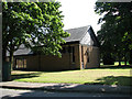
2
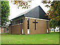
The church of St Edward the Confessor
This building was the station's chapel when RAF Coltishall was still an active airfield. It was inter-denominational and used for different services on different days. After the closure of the airfield the building was sold off by the Catholic church and the Church of England purchased it. The pews and the altar were removed along with the tapestry above the altar and the stained glass window associated with RAF Coltishall. For an interior view see > http://www.geograph.org.uk/photo/4172690.
Image: © Evelyn Simak
Taken: 19 Sep 2014
0.04 miles
3
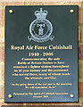
The church of St Edward the Confessor (plaque)
The plaque, which can be seen behind the altar, was presented to the church by the Spirit of Coltishall Association in October 2008.
This building was the station's chapel when RAF Coltishall was still an active airfield. It was inter-denominational and used for different services on different days. After the closure of the airfield the building was sold off by the Catholic church and the Church of England purchased it. The pews and the altar were removed along with the tapestry above the altar and the stained glass window associated with RAF Coltishall. For an exterior view see > http://www.geograph.org.uk/photo/4172685.
Image: © Evelyn Simak
Taken: 19 Sep 2014
0.05 miles
4
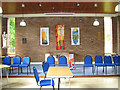
The church of St Edward the Confessor (interior)
This building was the station's chapel when RAF Coltishall was still an active airfield. It was inter-denominational and used for different services on different days. After the closure of the airfield the building was sold off by the Catholic church and the Church of England purchased it. The pews and the altar were removed along with the tapestry above the altar and the stained glass window associated with RAF Coltishall. For an exterior view see > http://www.geograph.org.uk/photo/4172685.
Image: © Evelyn Simak
Taken: 19 Sep 2014
0.05 miles
5
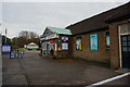
Thorougoods Select Convenience Store
At the former RAF Coltishall.
Image: © Ian S
Taken: 6 Nov 2018
0.06 miles
6
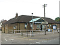
Thorougoods supermarket
This used to be the Spar Supermarket and Post Office for RAF Coltishall. Before that this building used to be the NAAFI (building 45); it incorporated part of the telephone exchange dating from the 1930s. For a picture taken in 2007 see > http://www.geograph.org.uk/photo/538716.
Image: © Evelyn Simak
Taken: 19 Sep 2014
0.06 miles
8
Church of St Edward the Confessor, Coltishall
This building was the station's chapel when RAF Coltishall was still an active airfield. It was inter-denominational and used for different services on different days.
Image: © Evelyn Simak
Taken: 28 Aug 2007
0.06 miles
10
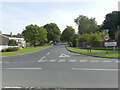
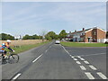
Housing developer's sign on Hautbois Road
Planned as a bomber station, the construction of Royal Air Force Coltishall began in February 1939. It was pressed into use as a fighter station in May 1940 while still incomplete, and disbanded on April 1st 2006. The site has meanwhile been developed for private housing.
Image: © Evelyn Simak
Taken: 28 Aug 2007
0.07 miles