IMAGES TAKEN NEAR TO
Marsham Road, NORWICH, NR10 5HN
Introduction
This page details the photographs taken nearby to Marsham Road, NR10 5HN by members of the Geograph project.
The Geograph project started in 2005 with the aim of publishing, organising and preserving representative images for every square kilometre of Great Britain, Ireland and the Isle of Man.

There are currently over 7.5m images from over14,400 individuals and you can help contribute to the project by visiting https://www.geograph.org.uk
Image Map
Images are licensed for reuse under creativecommons.org/licenses/by-sa/2.0
Notes
- Clicking on the map will re-center to the selected point.
- The higher the marker number, the further away the image location is from the centre of the postcode.
Image Listing (83 Images Found)
Images are licensed for reuse under creativecommons.org/licenses/by-sa/2.0
Image
Details
Distance
1
Crossroads in the village of Brampton
Aylsham Road meets The Street.
Image: © Evelyn Simak
Taken: 5 Apr 2009
0.01 miles
3
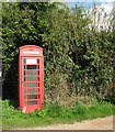
Red telephone kiosk
This old K6 telephone box is located by the junction of Aylsham Road and The Street.
Image: © Evelyn Simak
Taken: 5 Apr 2009
0.02 miles
5
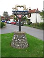
Brampton Village Sign
Unusual village sign in Brampton, about 2½ miles south-east of Aylsham.
Image: © G Laird
Taken: 28 Oct 2017
0.04 miles
6
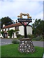
Brampton village sign
The sign is based on a Roman artefact discovered in the village which can now be seen in Norwich Castle Museum. https://www.geograph.org.uk/photo/6797386
Image: © Adrian S Pye
Taken: 11 Sep 2007
0.04 miles
7
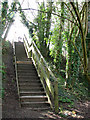
Steps to Brampton Station
The wooden steps lead up the embankment to Brampton Station > http://www.geograph.org.uk/photo/1236379 and to the Bure Valley Railway Walk.
Image: © Evelyn Simak
Taken: 5 Apr 2009
0.04 miles
8
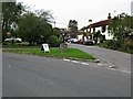
Road Junction in Brampton
With the village sign on the triangular traffic island.
Image: © G Laird
Taken: 28 Oct 2017
0.05 miles
9
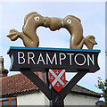
Brampton (Norfolk) village sign
They are thought to be dolphins, and are based on an artefact discovered in Brampton during an excavation in 1974. Made of copper alloy, they are thought to have formed a decorative handle for an item of Roman furniture. When in use the dolphins would usually be seen inverted.
On each facet of the post are carvings. Two crossed keys representing the church of St Peter, and or the former Cross Keys public house. Because around 140 kilns have been discovered in the parish a number of pots are carved onto another. A Roman galleon is shown on the River Bure which was navigable to large ships during the Roman period. The fourth carving, seemingly of the Virgin Mary, may allude to Maid's Head, another pub which closed in 1962. The shields represent the Brampton and a marriage between the Brampton and Marsham family. https://www.geograph.org.uk/photo/4295947
Image: © Adrian S Pye
Taken: 11 Sep 2007
0.05 miles
10
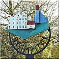
Brampton village sign (old)
The old sign depicts two local buildings, the village church and Oxnead mill which stands disused on the other side of the River Bure. https://www.geograph.org.uk/photo/6800213
Image: © Adrian S Pye
Taken: 14 Dec 2020
0.05 miles