IMAGES TAKEN NEAR TO
Leathercoat Lane, NORWICH, NR10 5BJ
Introduction
This page details the photographs taken nearby to Leathercoat Lane, NR10 5BJ by members of the Geograph project.
The Geograph project started in 2005 with the aim of publishing, organising and preserving representative images for every square kilometre of Great Britain, Ireland and the Isle of Man.

There are currently over 7.5m images from over14,400 individuals and you can help contribute to the project by visiting https://www.geograph.org.uk
Image Map
Images are licensed for reuse under creativecommons.org/licenses/by-sa/2.0
Notes
- Clicking on the map will re-center to the selected point.
- The higher the marker number, the further away the image location is from the centre of the postcode.
Image Listing (108 Images Found)
Images are licensed for reuse under creativecommons.org/licenses/by-sa/2.0
Image
Details
Distance

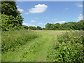
4
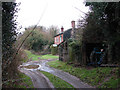
House on Leathercoat Lane
This view was taken from Leathercoat Lane, an access track doubling as a public bridleway, which turns off School Road. It leads in southerly direction and emerges on an unnamed road a short distance east of Brook Farm.
Image: © Evelyn Simak
Taken: 15 Dec 2008
0.02 miles
5
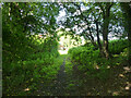
View north along public bridleway
This view was taken from Leathercoat Lane, an access track doubling as a public bridleway, which turns off School Road. It leads in southerly direction and emerges on an unnamed road a short distance east of Brook Farm.
Image: © Evelyn Simak
Taken: 15 Dec 2008
0.02 miles
7

Approaching Leathercoat Lane
From the public footpath which links with Long Common Lane further to the west.
Image: © Evelyn Simak
Taken: 15 Dec 2008
0.03 miles
8

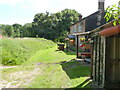
Path alongside a drain
This public footpath (it runs parallel to the drain on its northern side, not as is marked on OS maps to the south of it) turns off Leathercoat Lane in easterly direction and re-connects with School Road further to the northeast.
Image: © Evelyn Simak
Taken: 15 Dec 2008
0.03 miles
10

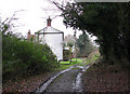
Footpath-bridleway junction
The track, doubling as a public bridleway, is Leathercoat Lane - it turns off School Road, leading in southerly direction and emerging on an unnamed road a short distance east of Brook Farm. A public footpath > http://www.geograph.org.uk/photo/1080786 turns off the bridleway (mid-distance, left), linking with Long Common Lane further to the west. Another path > http://www.geograph.org.uk/photo/1080848 turns off in easterly direction, linking back to School Road. The house seen in the background is the only one located on Leathercoat Lane.
Image: © Evelyn Simak
Taken: 15 Dec 2008
0.04 miles