IMAGES TAKEN NEAR TO
Broomhill Lane, NORWICH, NR10 4QY
Introduction
This page details the photographs taken nearby to Broomhill Lane, NR10 4QY by members of the Geograph project.
The Geograph project started in 2005 with the aim of publishing, organising and preserving representative images for every square kilometre of Great Britain, Ireland and the Isle of Man.

There are currently over 7.5m images from over14,400 individuals and you can help contribute to the project by visiting https://www.geograph.org.uk
Image Map
Images are licensed for reuse under creativecommons.org/licenses/by-sa/2.0
Notes
- Clicking on the map will re-center to the selected point.
- The higher the marker number, the further away the image location is from the centre of the postcode.
Image Listing (5 Images Found)
Images are licensed for reuse under creativecommons.org/licenses/by-sa/2.0
Image
Details
Distance
1
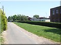
Looking along Broomhill Lane, Reepham
Reepham High School buildings on the right.
Image: © Ian Robertson
Taken: 3 Jun 2007
0.03 miles
3
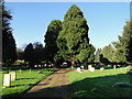
Reepham and Whitwell cemetery
The cemetery contains four War Graves
Image: © Adrian S Pye
Taken: 6 Nov 2017
0.07 miles
4
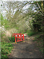
Erosion on path
Rain water has eroded and carried away a section of path, leaving a large, fenced-off hole. This sunken lane links Whitwell station with the village of Reepham, leading in northerly direction and emerging by Reepham High School > http://www.geograph.org.uk/photo/454603.
Image: © Evelyn Simak
Taken: 15 Apr 2009
0.22 miles
5
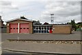
Reepham fire station
Reepham fire station, 36 School Road, Reepham, Norfolk
Image: © Kevin Hale
Taken: 6 Jun 2009
0.24 miles