IMAGES TAKEN NEAR TO
Holt Road, NORWICH, NR10 4QQ
Introduction
This page details the photographs taken nearby to Holt Road, NR10 4QQ by members of the Geograph project.
The Geograph project started in 2005 with the aim of publishing, organising and preserving representative images for every square kilometre of Great Britain, Ireland and the Isle of Man.

There are currently over 7.5m images from over14,400 individuals and you can help contribute to the project by visiting https://www.geograph.org.uk
Image Map
Images are licensed for reuse under creativecommons.org/licenses/by-sa/2.0
Notes
- Clicking on the map will re-center to the selected point.
- The higher the marker number, the further away the image location is from the centre of the postcode.
Image Listing (11 Images Found)
Images are licensed for reuse under creativecommons.org/licenses/by-sa/2.0
Image
Details
Distance
1
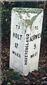
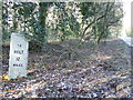
Old Milepost by the B1149, Holt Road, Haveringland Parish
Concrete post by the B1149, in parish of HAVERINGLAND (BROADLAND District), approximately 20yds North of South edge of Great Wood, on the verge overshadowed by trees, on West side of road. NCC concrete, erected by the County Council in the 19th/20th century.
Inscription reads:-
: TO / HOLT / 12 / MILES : : NCC / MAIN ROAD :: HAVERINGLAND : : TO / NORWICH / 9 / MILES :
Milestone Society National ID: NO_NH09.
Image: © CW Haines
Taken: 22 Nov 2002
0.12 miles
2
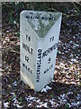
Old Milestone
Old milestone on the B1149 near to Eastgate, Norfolk. For overall view see http://www.geograph.org.uk/photo/1703436
Image: © Keith Evans
Taken: 11 Feb 2010
0.12 miles
4
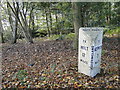
To Holt 12
Old milestone on the B1149 near to Eastgate, Norfolk. For close up view see http://www.geograph.org.uk/photo/1703433
Image: © Keith Evans
Taken: 11 Feb 2010
0.18 miles
5
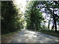
Holt Road, 12 miles from Holt on the B1149
Image: © Adrian S Pye
Taken: 23 Oct 2018
0.20 miles
6
Sign affixed to tree
Signs are affixed to trees at regular intervals, warning walkers that this is a shooting area and to keep dogs on their leads.
The start of this track is on the B1149 (Holt Road) in adjacent grid square > http://www.geograph.org.uk/photo/972652. It leads through Haveringland Wood > http://www.geograph.org.uk/photo/972667 with this section doubling as a public footpath > http://www.geograph.org.uk/photo/972775 which veers off further to the southwest. The forestry track soon changes direction to southeasterly, leaving Haveringland Wood behind and entering Great Wood. Further to the southeast it again changes direction, now leading southwesterly towards Haveringland Hall Park > http://www.geograph.org.uk/photo/973022.
Image: © Evelyn Simak
Taken: 21 Sep 2008
0.20 miles
8
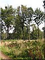
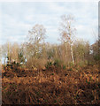
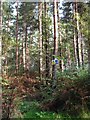
Beeches and Birches
Beech and birch trees are growing on this clearing in Haveringland Wood.
Image: © Evelyn Simak
Taken: 21 Sep 2008
0.24 miles
9
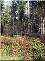
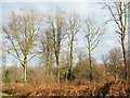
Vegetation beside the track
Autumn colours are appearing in the vegetation growing densely beside the forestry road which starts on the B1149 (Holt Road) in adjacent grid square > http://www.geograph.org.uk/photo/972652. It leads through Haveringland Wood > http://www.geograph.org.uk/photo/972667 with this section doubling as a public footpath > http://www.geograph.org.uk/photo/972775 which veers off further to the southwest. The forestry track soon changes direction to southeasterly, leaving Haveringland Wood behind and entering Great Wood. Further to the southeast it again changes direction, now leading southwesterly towards Haveringland Hall Park > http://www.geograph.org.uk/photo/973022.
Image: © Evelyn Simak
Taken: 21 Sep 2008
0.24 miles