IMAGES TAKEN NEAR TO
Cawston, NORWICH, NR10 4PW
Introduction
This page details the photographs taken nearby to NR10 4PW by members of the Geograph project.
The Geograph project started in 2005 with the aim of publishing, organising and preserving representative images for every square kilometre of Great Britain, Ireland and the Isle of Man.

There are currently over 7.5m images from over14,400 individuals and you can help contribute to the project by visiting https://www.geograph.org.uk
Image Map
Images are licensed for reuse under creativecommons.org/licenses/by-sa/2.0
Notes
- Clicking on the map will re-center to the selected point.
- The higher the marker number, the further away the image location is from the centre of the postcode.
Image Listing (38 Images Found)
Images are licensed for reuse under creativecommons.org/licenses/by-sa/2.0
Image
Details
Distance
1
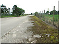
Entrance to Stump Cross Farm
This view was taken looking from the farmhouse towards the exit onto Haveringland Road. The farmhouse stands in the centre of one of the aircraft dispersals beside the perimeter track seen here.
Image: © Evelyn Simak
Taken: 19 Jul 2014
0.02 miles
2
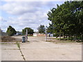
Entrance to Stump Cross & Haveringland Farms
Off Norwich Road
Image: © Geographer
Taken: 26 Sep 2013
0.05 miles
3
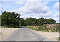
Norwich Road, Haveringland
At the entrance to Stump Cross & Haveringland Farms & St.Peter's Church
Road no.C278
Image: © Geographer
Taken: 26 Sep 2013
0.06 miles
4
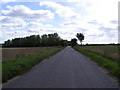
Norwich Road, Haveringland
Near Stump Cross Farm
Road no.C278
Image: © Geographer
Taken: 26 Sep 2013
0.06 miles
5
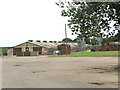
Poultry houses at Stump Cross Farm
The poultry houses are situated on part of the former perimeter track of RAF Swannington.
Image: © Evelyn Simak
Taken: 19 Jul 2014
0.06 miles
6
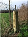
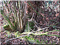
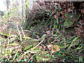
Old Wayside Cross near Stump Cross Farm, Haveringland parish
Stump Cross, old shaft by the UC road, in parish of Haveringland (Broadland District), North of entrance to Stump Cross Farm, on verge, at corner of wire netting fence.
Scheduled Monument.
List Entry Number: 1018301 https://historicengland.org.uk/listing/the-list/list-entry/1018301
Surveyed
Milestone Society National ID: NOBD_HAV
Image: © Milestone Society
Taken: Unknown
0.09 miles
7
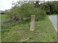
Haveringland Stump Cross
The remains of a mediaeval stone cross, standing at the side of the Cawston to Norwich road on the boundary between Haveringland and Brandiston.
On a 1738 map of Brandiston town land, this is called Stantlin Cross, described as being 1.8m (6 feet) high. It was also known as Lance's Cross. It might even be Bee's Cross from elsewhere and moved here presumably when no one was looking. (Norfolk Heritage)
Image: © Adrian S Pye
Taken: 15 Apr 2019
0.09 miles
8
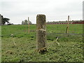
Haveringland Stump Cross
The remains of a mediaeval stone cross, standing at the side of the Cawston to Norwich road on the boundary between Haveringland and Brandiston.
On a 1738 map of Brandiston town land, this is called Stantlin Cross, described as being 1.8m (6 feet) high. It was also known as Lance's Cross. It might even be Bee's Cross from elsewhere and moved here presumably when no one was looking. (Norfolk Heritage)
Image: © Adrian S Pye
Taken: 15 Apr 2019
0.09 miles
9
Remains of the Bombing trainer building
This would seem to have been the boiler room. The Bombing trainer was one of many buildings that once stood on the former Technical site of RAF Swannington, which was an active airfield during WW2.
Image: © Evelyn Simak
Taken: 23 Jan 2015
0.10 miles
10
Remains of the Bombing trainer building
On the former Technical site of RAF Swannington which was an active airfield during WW2.
Image: © Evelyn Simak
Taken: 23 Jan 2015
0.10 miles