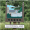
IMAGES TAKEN NEAR TO
Haveringland, NORWICH, NR10 4PT

Introduction

This page details the photographs taken nearby to NR10 4PT by members of the Geograph project.

The Geograph project started in 2005 with the aim of publishing, organising and preserving representative images for every square kilometre of Great Britain, Ireland and the Isle of Man.

There are currently over 7.5m images from over14,400 individuals and you can help contribute to the project by visiting https://www.geograph.org.uk

Image Map


Images are licensed for reuse under creativecommons.org/licenses/by-sa/2.0
Notes
  • Clicking on the map will re-center to the selected point.
  • The higher the marker number, the further away the image location is from the centre of the postcode.

Image Listing (31 Images Found)

Images are licensed for reuse under creativecommons.org/licenses/by-sa/2.0
  • ...
Image
Details
Distance
1
The stocks and village sign
Beside Haveringland Road. For details see > Image and Image
Image: © Evelyn Simak Taken: 6 Apr 2008
0.01 miles
2
Haveringland village sign (detail)
The sign incorporates a replica of the village stocks which are standing close by. https://www.geograph.org.uk/photo/4571010 It shows a RAF Mosquito flying over the church of St Peter which stands on what was the very edge of the perimeter track of the wartime airfield. The other building is or was Haveringland Hall which had to be demolished after it was requisitioned in WW2 and damaged beyond by the Royal Air Force. http://www.lostheritage.org.uk/houses/lh_norfolk_haveringlandhall_info_gallery.html https://www.geograph.org.uk/photo/4571025
Image: © Adrian S Pye Taken: 15 Jul 2015
0.01 miles
3
Haveringland village sign
The sign depicts the stocks, which stand adjacent to the sign, the church, Haveringland Hall and a Mosquito fighter/bomber, which were based at the Swannington Airfield or Haveringland Airfield as it was more commonly called. Detail - https://www.geograph.org.uk/photo/6678210
Image: © Adrian S Pye Taken: 15 Jul 2015
0.01 miles
4
Haveringland stocks
Image: © Adrian S Pye Taken: 15 Jul 2015
0.01 miles
5
The stocks and village sign at Haveringland
Image: © Adrian S Pye Taken: 15 Jul 2015
0.01 miles
6
Haveringland Road, Haveringland
At the junction with Abbey Lane Road No.C278
Image: © Geographer Taken: 24 Jun 2020
0.01 miles
7
Haveringland Road, Haveringland
At the junction with Abbey Lane Road No.C278
Image: © Geographer Taken: 24 Jun 2020
0.02 miles
8
The Old Kings Head
The Old Kings Head pub was closed by 1958 and is now a private dwelling. It is located opposite the stocks beside Haveringland Road > Image
Image: © Evelyn Simak Taken: 6 Apr 2008
0.02 miles
9
Village sign & stocks, Haveringland
Image: © Helen Steed Taken: 6 Aug 2013
0.02 miles
10
Village sign
Beside Haveringland Road > Image
Image: © Evelyn Simak Taken: 6 Apr 2008
0.03 miles
  • ...