IMAGES TAKEN NEAR TO
Orchard Lane, NORWICH, NR10 4NP
Introduction
This page details the photographs taken nearby to Orchard Lane, NR10 4NP by members of the Geograph project.
The Geograph project started in 2005 with the aim of publishing, organising and preserving representative images for every square kilometre of Great Britain, Ireland and the Isle of Man.

There are currently over 7.5m images from over14,400 individuals and you can help contribute to the project by visiting https://www.geograph.org.uk
Image Map
Images are licensed for reuse under creativecommons.org/licenses/by-sa/2.0
Notes
- Clicking on the map will re-center to the selected point.
- The higher the marker number, the further away the image location is from the centre of the postcode.
Image Listing (30 Images Found)
Images are licensed for reuse under creativecommons.org/licenses/by-sa/2.0
Image
Details
Distance
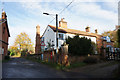
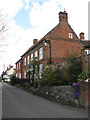
1
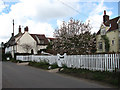
Cottages on The Moor
The Moor is an area on the eastern fringe of the market town of Reepham; 'moor' in this context means low, wet land. South of the cul-de-sac called The Moor is Booton Common, a SSSI of international importance, managed by the Norfolk Wildlife Trust. Many of the historically interesting houses along this road were altered in Victorian times and the only remaining thatched cottage is located on the junction with Orchard Lane.
Image: © Evelyn Simak
Taken: 8 Apr 2008
0.06 miles
2
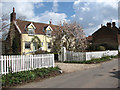
Anniversary Cottage
The Moor is an area on the eastern fringe of the market town of Reepham; 'moor' in this context means low, wet land. South of the cul-de-sac called The Moor is Booton Common, a SSSI of international importance, managed by the Norfolk Wildlife Trust. Many of the historically interesting houses along this road were altered in Victorian times and the only remaining thatched cottage is located on the junction with Orchard Lane.
Image: © Evelyn Simak
Taken: 8 Apr 2008
0.07 miles
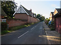
3
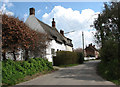
Thatched cottage
The Moor is an area on the eastern fringe of the market town of Reepham; 'moor' in this context means low, wet land. South of the cul-de-sac called The Moor is Booton Common, a SSSI of international importance, managed by the Norfolk Wildlife Trust. Many of the historically interesting houses along this road were altered in Victorian times and the only remaining thatched cottage (seen here) is located on the junction with Orchard Lane.
Image: © Evelyn Simak
Taken: 8 Apr 2008
0.07 miles
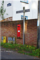
7
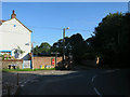
Postbox, Reepham
At the end of New Road.
Image: © Hugh Venables
Taken: 22 Sep 2017
0.09 miles
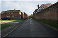
8
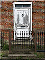
Cottage door
Entrance to one of the cottages called the Old Monastery, a row of cottages dating from the 18th century; the origin of their name is unknown, there has never been a monastery in Reepham.
The Moor is an area on the eastern fringe of the market town of Reepham; 'moor' in this context means low, wet land. South of the cul-de-sac called The Moor is Booton Common, a SSSI of international importance, managed by the Norfolk Wildlife Trust. Many of the historically interesting houses along this road were altered in Victorian times and the only remaining thatched cottage is located on the junction with Orchard Lane.
Image: © Evelyn Simak
Taken: 8 Apr 2008
0.09 miles
9
Ye Old Monastery
A row of cottages dating from the 18th century; the origin of their name is unknown, there has never been a monastery in Reepham.
The Moor is an area on the eastern fringe of the market town of Reepham; 'moor' in this context means low, wet land. South of the cul-de-sac called The Moor is Booton Common, a SSSI of international importance, managed by the Norfolk Wildlife Trust. Many of the historically interesting houses along this road were altered in Victorian times and the only remaining thatched cottage is located on the junction with Orchard Lane.
Image: © Evelyn Simak
Taken: 8 Apr 2008
0.09 miles