IMAGES TAKEN NEAR TO
Coles Way, NORWICH, NR10 4LW
Introduction
This page details the photographs taken nearby to Coles Way, NR10 4LW by members of the Geograph project.
The Geograph project started in 2005 with the aim of publishing, organising and preserving representative images for every square kilometre of Great Britain, Ireland and the Isle of Man.

There are currently over 7.5m images from over14,400 individuals and you can help contribute to the project by visiting https://www.geograph.org.uk
Image Map
Images are licensed for reuse under creativecommons.org/licenses/by-sa/2.0
Notes
- Clicking on the map will re-center to the selected point.
- The higher the marker number, the further away the image location is from the centre of the postcode.
Image Listing (157 Images Found)
Images are licensed for reuse under creativecommons.org/licenses/by-sa/2.0
Image
Details
Distance
3
The Cutting Station, Reepham
Hairdresser on Station Plain.
Image: © JThomas
Taken: 10 Oct 2024
0.11 miles
5
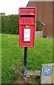
Elizabeth II postbox on Station Road, Reepham
Postbox No. NR10 1018.
Image: © JThomas
Taken: 10 Oct 2024
0.12 miles


9
Reepham Methodist Church
Station Road, Reepham.
Image: © Ian S
Taken: 9 Nov 2018
0.15 miles
10
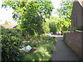
Footpath at Reepham
Presumably the garden on the left belongs to the house on the right.
Image: © Jonathan Thacker
Taken: 4 Jun 2012
0.15 miles