IMAGES TAKEN NEAR TO
NP9 8LA
Introduction
This page details the photographs taken nearby to NP9 8LA by members of the Geograph project.
The Geograph project started in 2005 with the aim of publishing, organising and preserving representative images for every square kilometre of Great Britain, Ireland and the Isle of Man.

There are currently over 7.5m images from over14,400 individuals and you can help contribute to the project by visiting https://www.geograph.org.uk
Image Map
Images are licensed for reuse under creativecommons.org/licenses/by-sa/2.0
Notes
- Clicking on the map will re-center to the selected point.
- The higher the marker number, the further away the image location is from the centre of the postcode.
Image Listing (250 Images Found)
Images are licensed for reuse under creativecommons.org/licenses/by-sa/2.0
Image
Details
Distance
1
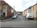
Llewellin (or Llewellyn) Street, Newport
Viewed from Somerton Road. Two name signs on the left of the view contradict each other. The older name sign on the wall ends in -in whereas the newer sign near ground level ends in -yn. This pattern also occurs on the Newport City Council website, where both spellings are used - though not, so far as I have seen, on the same webpage.
Image: © Jaggery
Taken: 24 Sep 2009
0.00 miles
2
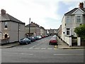
Mansel Street, Newport
Viewed across Somerton Road from the corner of Linden Road. http://www.geograph.org.uk/photo/1964187
Image: © Jaggery
Taken: 24 Sep 2009
0.00 miles
3
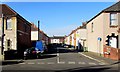
West along Mansel Street, Newport
Viewed across Somerton Road from the corner of Linden Road.
Mansel Street extends westwards for 90 metres, ending near a wall at the back of Kenilworth Road houses.
Image: © Jaggery
Taken: 16 Feb 2016
0.04 miles
4
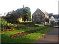
Beechwood Presbyterian Church
Beechwood Presbyterian Church, seen from Beechwood Park. Autumn leaves are beginning to fall.
Image: © David Roberts
Taken: 10 Oct 2009
0.05 miles
5
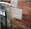
Ordnance Survey Cut Mark
This OS cut mark can be found on No28 Somerton Road. It marks a point 9.772m above mean sea level.
Image: © Adrian Dust
Taken: 30 Jul 2021
0.05 miles
6
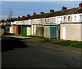
Conway Road lockup garages, Newport
Near the corner of Somerton Road.
Image: © Jaggery
Taken: 16 Feb 2016
0.05 miles
7
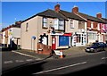
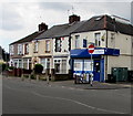
MA Somerton Fish Bar, Newport
Fish and chips shop at 26 Somerton Road, on the corner of Llewellyn Street.
Image: © Jaggery
Taken: 16 Feb 2016
0.05 miles
8
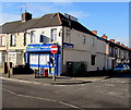
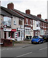
R&S Stores, Somerton Road, Newport
Lifestyle Express convenience store at 46 Somerton Road, on the corner of Balmoral Road.
Image: © Jaggery
Taken: 16 Feb 2016
0.05 miles
9
Somerton Stores, Somerton Road, Newport
Lifestyle Express store on the corner of Balmoral Road.
Image: © Jaggery
Taken: 21 Jun 2019
0.06 miles
10
MA Somerton Fish Bar, 26 Somerton Road, Newport
The fish & chips shop on the corner of Llewellyn Street is next door to Pisces Pets shop.
Image: © Jaggery
Taken: 21 Jun 2019
0.06 miles