IMAGES TAKEN NEAR TO
Llanbedr, CRICKHOWELL, NP8 1ST
Introduction
This page details the photographs taken nearby to NP8 1ST by members of the Geograph project.
The Geograph project started in 2005 with the aim of publishing, organising and preserving representative images for every square kilometre of Great Britain, Ireland and the Isle of Man.

There are currently over 7.5m images from over14,400 individuals and you can help contribute to the project by visiting https://www.geograph.org.uk
Image Map
Images are licensed for reuse under creativecommons.org/licenses/by-sa/2.0
Notes
- Clicking on the map will re-center to the selected point.
- The higher the marker number, the further away the image location is from the centre of the postcode.
Image Listing (7 Images Found)
Images are licensed for reuse under creativecommons.org/licenses/by-sa/2.0
Image
Details
Distance
1
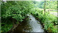
The Grwyne Fawr at Pen-y-bont
Flowing away from camera towards the confluence with the Grwyne Fechan.
Image: © Jonathan Billinger
Taken: 10 Jun 2016
0.02 miles
2
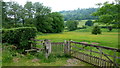
Footpath in the Vale of Grwyney
Valley between Y Fal and the main Black Mountains massif.
Path crosses the valley floor from Pen-y-bont to the through road.
Image: © Jonathan Billinger
Taken: 10 Jun 2016
0.03 miles
3
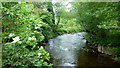
The Grwyne Fawr at Pen-y-bont, 2
Looking upstream.
Image: © Jonathan Billinger
Taken: 10 Jun 2016
0.04 miles
4
Footpath to Sugar Loaf
A footpath sign beside Dyffryn on a no through road. The footpath eventually leads to Sugar Loaf.
Image: © Philip Halling
Taken: 23 Nov 2013
0.12 miles
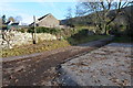
5
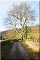
No through road
No through road near Dryfryn in the shadows of Sugar Loaf.
Image: © Philip Halling
Taken: 23 Nov 2013
0.13 miles
6
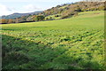
Farmland in Grwyne Fawr valley
Farmland in Grwyne Fawr valley with Crug Hywel (Table Mountain) visible on the horizon.
Image: © Philip Halling
Taken: 23 Nov 2013
0.15 miles
7
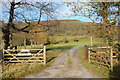
Private road entrance
This track which is a private drive to a residence but has the appearance of a right of way, but as a sign warns, it is not, there is no public right of way.
Image: © Philip Halling
Taken: 23 Nov 2013
0.25 miles