IMAGES TAKEN NEAR TO
Brecon Road, CRICKHOWELL, NP8 1SE
Introduction
This page details the photographs taken nearby to Brecon Road, NP8 1SE by members of the Geograph project.
The Geograph project started in 2005 with the aim of publishing, organising and preserving representative images for every square kilometre of Great Britain, Ireland and the Isle of Man.

There are currently over 7.5m images from over14,400 individuals and you can help contribute to the project by visiting https://www.geograph.org.uk
Image Map
Images are licensed for reuse under creativecommons.org/licenses/by-sa/2.0
Notes
- Clicking on the map will re-center to the selected point.
- The higher the marker number, the further away the image location is from the centre of the postcode.
Image Listing (46 Images Found)
Images are licensed for reuse under creativecommons.org/licenses/by-sa/2.0
Image
Details
Distance
1
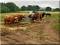
Bovine reception committee
At the start of my walk from Crickhowell to Table Mountain a reception committee has gathered. When faced with a gathering like this it pays to be bullish.
Image: © Alan Hughes
Taken: 2 Aug 2018
0.06 miles
2
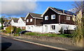
Oakfield Drive houses, Crickhowell
Viewed across Oakfield Drive on the approach to Crickhowell Community Primary School.
Image: © Jaggery
Taken: 22 Nov 2015
0.10 miles
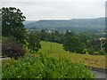
3
Field beside the footpath near Crickhowell
Summer is a-coming in down here in the warm Usk Valley.
Image: © Jeremy Bolwell
Taken: 25 Jun 2011
0.10 miles
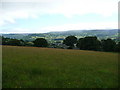
4
View over Crickhowell and the Usk Valley
Taken from the grounds of the Manor Hotel http://www.geograph.org.uk/photo/2070721 .
Image: © Robin Drayton
Taken: 31 Jul 2011
0.13 miles
5
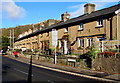
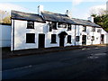
Victoria Terrace, Crickhowell
Row of houses extending for 55 metres alongside the A40 Brecon Road.
Image: © Jaggery
Taken: 22 Nov 2015
0.13 miles
6
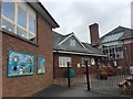
Crickhowell Community Primary School
Junior school in Crickhowell.
Image: © Alan Hughes
Taken: 2 Aug 2018
0.13 miles
7
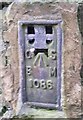
Ordnance Survey Flush Bracket (1086)
This OS Flush Bracket can be found on the north face of the Shelter. It marks a point 85.233m above mean sea level.
Image: © Adrian Dust
Taken: 19 Jan 2019
0.13 miles
8
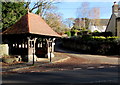
Shelter on a Crickhowell corner
Viewed across the A40 Brecon Road. There are benches and a disused drinking fountain inside. http://www.geograph.org.uk/photo/291938
Image: © Jaggery
Taken: 22 Nov 2015
0.13 miles
9
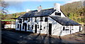
Red Indigo Crickhowell
Indian cuisine restaurant & takeaway viewed across the A40 Brecon Road in November 2015.
The building has been converted from a pub. In June 2011, the White Hart http://www.geograph.org.uk/photo/2468776 was here.
Image: © Jaggery
Taken: 22 Nov 2015
0.14 miles
10
Red Indigo, Crickhowell
Indian cuisine restaurant & takeaway viewed across the A40 Brecon Road in November 2015.
The building has been converted from a pub. In June 2011, the White Hart http://www.geograph.org.uk/photo/2468776 was here.
Image: © Jaggery
Taken: 22 Nov 2015
0.14 miles