IMAGES TAKEN NEAR TO
Cwmdu, CRICKHOWELL, NP8 1RS
Introduction
This page details the photographs taken nearby to NP8 1RS by members of the Geograph project.
The Geograph project started in 2005 with the aim of publishing, organising and preserving representative images for every square kilometre of Great Britain, Ireland and the Isle of Man.

There are currently over 7.5m images from over14,400 individuals and you can help contribute to the project by visiting https://www.geograph.org.uk
Image Map (Loading...)


Getting Data...Please wait
Leaflet Map data © OpenStreetMap
Images are licensed for reuse under creativecommons.org/licenses/by-sa/2.0
Notes
- Clicking on the map will re-center to the selected point.
- The higher the marker number, the further away the image location is from the centre of the postcode.
Image Listing (5 Images Found)
Images are licensed for reuse under creativecommons.org/licenses/by-sa/2.0
Image
Details
Distance
1
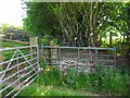
Penyrheol
Not a working farm anymore, I don't think.
Image: © Jeremy Bolwell
Taken: 11 May 2013
0.01 miles
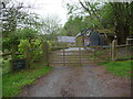
2
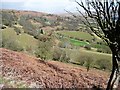
View over Penlan
This is a broad sweeping view north-east across the Rhiangoll towards Cwmdu.
Image: © Jonathan Billinger
Taken: 22 Mar 2008
0.08 miles
3
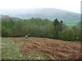
Stone on Cefn Moel
Could be a prehistoric standing stone. It is in an area rich in prehistoric monuments.
Image: © Jeremy Bolwell
Taken: 11 May 2013
0.17 miles
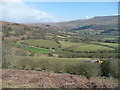
4
View from Cefn Moel
From the eastern slopes of Cefn Moel, looking north-east across the valley towards Pen Tir.
Image: © Graham Horn
Taken: 22 Mar 2008
0.17 miles