IMAGES TAKEN NEAR TO
St. Michaels Close, CRICKHOWELL, NP8 1RP
Introduction
This page details the photographs taken nearby to St. Michaels Close, NP8 1RP by members of the Geograph project.
The Geograph project started in 2005 with the aim of publishing, organising and preserving representative images for every square kilometre of Great Britain, Ireland and the Isle of Man.

There are currently over 7.5m images from over14,400 individuals and you can help contribute to the project by visiting https://www.geograph.org.uk
Image Map
Images are licensed for reuse under creativecommons.org/licenses/by-sa/2.0
Notes
- Clicking on the map will re-center to the selected point.
- The higher the marker number, the further away the image location is from the centre of the postcode.
Image Listing (82 Images Found)
Images are licensed for reuse under creativecommons.org/licenses/by-sa/2.0
Image
Details
Distance


3
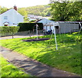
Children's play area in Cwmdu, Powys
Set back from the east side of the A479, the main road through the village.
Image: © Jaggery
Taken: 13 May 2018
0.04 miles
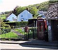
4

Houses near the village church, Cwmdu, Powys
The Church of St Michael & All Angels https://www.geograph.org.uk/photo/5800566 is behind the camera.
Image: © Jaggery
Taken: 13 May 2018
0.05 miles
5
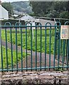
Bilingual No Smoking notice, Cwmdu, Powys
The notice on railings at the perimeter of a children's playground shows
"NO SMOKING" and the Welsh "DIM YSMYGU"
Image: © Jaggery
Taken: 10 Sep 2023
0.05 miles
6
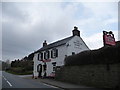
The Farmers Arms at Cwmdu, Powys
A well sited and conspicuous village roadside inn that always looks welcoming.
Image: © Jeremy Bolwell
Taken: 24 Mar 2013
0.05 miles
7
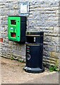
Green box on a stone wall, Cwmdu, Powys
The box located here https://www.geograph.org.uk/photo/7595389 contains a defibrillator.
A Powys County Council litter bin is also in view.
Image: © Jaggery
Taken: 10 Sep 2023
0.05 miles
8
Flaking red paint, Cwmdu, Powys
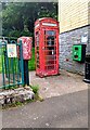
In September 2023 the red postbox and red phonebox
on the east side of the A479 are in need of a repaint.
Image: © Jaggery
Taken: 10 Sep 2023
0.05 miles
9
Queen Elizabeth II postbox and a red phonebox, Cwmdu, Powys
Alongside a bus stop and shelter https://www.geograph.org.uk/photo/5774361 on the east side of the A479, the main road through the village.
Image: © Jaggery
Taken: 13 May 2018
0.05 miles
10
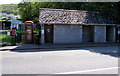
X12 bus stop and shelter in Cwmdu, Powys
Alongside the A479, the main road through the village. The timetable on display in May 2018 shows that no buses stop here six days a week. The exception is on Tuesdays when there is a bus departure at 10:22am on route X12 to Abergavenny and a departure at 14:27 on route X12 to Builth Wells. The public toilets in the shelter are permanently closed.
Image: © Jaggery
Taken: 13 May 2018
0.05 miles