IMAGES TAKEN NEAR TO
Beechwood Road, CRICKHOWELL, NP8 1PL
Introduction
This page details the photographs taken nearby to Beechwood Road, NP8 1PL by members of the Geograph project.
The Geograph project started in 2005 with the aim of publishing, organising and preserving representative images for every square kilometre of Great Britain, Ireland and the Isle of Man.

There are currently over 7.5m images from over14,400 individuals and you can help contribute to the project by visiting https://www.geograph.org.uk
Image Map
Images are licensed for reuse under creativecommons.org/licenses/by-sa/2.0
Notes
- Clicking on the map will re-center to the selected point.
- The higher the marker number, the further away the image location is from the centre of the postcode.
Image Listing (86 Images Found)
Images are licensed for reuse under creativecommons.org/licenses/by-sa/2.0
Image
Details
Distance
1
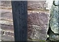
Ordnance Survey Cut Mark
This OS cut mark can be found on the Ty Saer Coed. It marks a point 86.450m above mean sea level.
Image: © Adrian Dust
Taken: 19 Jan 2019
0.11 miles
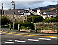
2
Bilingual priority over oncoming vehicles sign, Llangattock
The Welsh and English sign faces Hillside Road.
Image: © Jaggery
Taken: 22 Nov 2015
0.11 miles
3

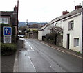
Horse Shoe Inn, Llangattock
Viewed from Park Drive. The pub is located on Hillside Road, a short distance from the centre of the village. This view http://www.geograph.org.uk/photo/1413913 taken 3 years earlier shows the pub painted white.
Update November 2015. The pub has closed down. http://www.geograph.org.uk/photo/4748049
Image: © Jaggery
Taken: 17 Jun 2012
0.11 miles
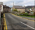
4
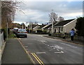
Park Drive, Llangattock
Along Park Drive from the corner of Hillside Road towards the right turn into Beaufort Avenue.
The white-edged rectangle painted on the road surface marks a parking area reserved for Blue Badge holders.
Image: © Jaggery
Taken: 22 Nov 2015
0.12 miles
5
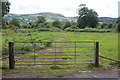
Gated track on west of Llangattock Village
Track off entrance road Image to Park Farm. Mynydd Llangatwg is on the sky line.
Image: © M J Roscoe
Taken: 10 Jul 2020
0.13 miles
6
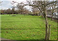
Park and children's play area in Llangattock
Between Hillside Road and Park Drive.
Image: © Jaggery
Taken: 22 Nov 2015
0.13 miles
7
Signpost in a hedge, Llangattock
On the corner of Swan Lane and Hillside Road, half a mile from Dardy,
three-quarters of a mile from Crickhowell and seven and a quarter miles from Beaufort.
Image: © Jaggery
Taken: 22 Nov 2015
0.13 miles
8
No parking anywhere here, Swan Lane, Llangattock
In addition to the double yellow lines on both sides of Swan Lane
indicating no parking at any time, a notice at the edge of a track shows NO PARKING.
Image: © Jaggery
Taken: 22 Nov 2015
0.13 miles
9
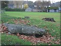
Carn Coch, Llangattock
Neolithic Burial Chamber.
Image: © Chris Andrews
Taken: 21 Nov 2012
0.14 miles
10
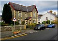
Park View, Llangattock
Stone house viewed across Hillside Road.
Image: © Jaggery
Taken: 22 Nov 2015
0.14 miles