IMAGES TAKEN NEAR TO
St. Catwgs Close, CRICKHOWELL, NP8 1PJ
Introduction
This page details the photographs taken nearby to St. Catwgs Close, NP8 1PJ by members of the Geograph project.
The Geograph project started in 2005 with the aim of publishing, organising and preserving representative images for every square kilometre of Great Britain, Ireland and the Isle of Man.

There are currently over 7.5m images from over14,400 individuals and you can help contribute to the project by visiting https://www.geograph.org.uk
Image Map
Images are licensed for reuse under creativecommons.org/licenses/by-sa/2.0
Notes
- Clicking on the map will re-center to the selected point.
- The higher the marker number, the further away the image location is from the centre of the postcode.
Image Listing (122 Images Found)
Images are licensed for reuse under creativecommons.org/licenses/by-sa/2.0
Image
Details
Distance
1
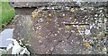
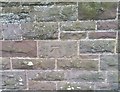
Ordnance Survey Cut Mark
This OS cut mark can be found on the south face of St Catwg's Church. It marks a point 79.970m above mean sea level.
Image: © Adrian Dust
Taken: 19 Jan 2019
0.01 miles
2
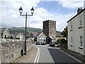
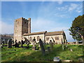
Llangattock
The substantial tower of St. Catwg's church is at the north end of a densely-built village on the opposite bank over the river Usk from Crickhowell.
Image: © Jonathan Billinger
Taken: 27 Jul 2007
0.02 miles
3
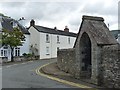
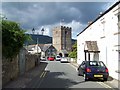
Entering Llangattock from the west
The alcove in the wall contains a drinking fountain http://www.geograph.org.uk/photo/3035114 .
Image: © Robin Drayton
Taken: 30 Aug 2012
0.02 miles
4
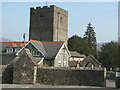
Llangattock Church
Llangattock lies between the River Usk and the Monmouthshire and Brecon Canal.
Image: © David M Clark
Taken: 12 Mar 2014
0.02 miles
5
Ordnance Survey Cut Mark
This OS cut mark can be found on the north face of the Memorial Hall Church House. It marks a point 80.793m above mean sea level.
Image: © Adrian Dust
Taken: 19 Jan 2019
0.02 miles
6
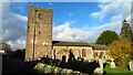
St Catwg's Church, Llangattock
St Catwg or Cadoc is one of the most famous of the Welsh saints, founding numerous monastic colonies, , most notably Llancarfan in the Vale of Glamorgan, where he was returned and buried after being killed by the Saxons in the Celtic Kingdom of Calchfynedd.
Records show a church on this site in the 6th century. The arcade dates from the 14th century but much of the church has been rebuilt in the 18th and 19th centuries. The windows date from 1843 though they may be copies of the earlier windows. There are some fine 18th century memorials in the church.
Listed as a Grade II by Cadw.
Image: © Colin Cheesman
Taken: 22 Feb 2019
0.02 miles
8
Llangattock
Looking towards the tower of St Catwg's church
Image: © Geoff Pick
Taken: 12 Aug 2010
0.02 miles
9
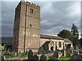
Llangattock church
The church of St Cattwg in Llangattock has a 16thC tower which looks a little too large for the rest of the building. Inside there are 14thC arcades, but much of the exterior is a rebuilding of the 18th & 19th centuries.
Image: © Gordon Hatton
Taken: 12 Apr 2015
0.02 miles
10
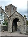
Stone lych gate at St Catwg's church, Llangattock
Image: © Ruth Sharville
Taken: 24 Aug 2010
0.03 miles