IMAGES TAKEN NEAR TO
Llangattock, CRICKHOWELL, NP8 1PH
Introduction
This page details the photographs taken nearby to NP8 1PH by members of the Geograph project.
The Geograph project started in 2005 with the aim of publishing, organising and preserving representative images for every square kilometre of Great Britain, Ireland and the Isle of Man.

There are currently over 7.5m images from over14,400 individuals and you can help contribute to the project by visiting https://www.geograph.org.uk
Image Map
Images are licensed for reuse under creativecommons.org/licenses/by-sa/2.0
Notes
- Clicking on the map will re-center to the selected point.
- The higher the marker number, the further away the image location is from the centre of the postcode.
Image Listing (107 Images Found)
Images are licensed for reuse under creativecommons.org/licenses/by-sa/2.0
Image
Details
Distance
1

Old Six Bells, Owens Row, Llangattock
This former Public House was built in three phases. The oldest part is at the southern end (furthest from camera) and internal features suggest a 17th century date. The middle part is probably 18th century to early 19th century and is characterised by hoodmoulds to the front. The northern section is Victorian. The house was a pub until the mid 20th century.
There are a set of steps beyond the porch to allow people to ascend to their carriages.
Listed as Grade II by Cadw.
Image: © Colin Cheesman
Taken: 22 Feb 2019
0.01 miles
2
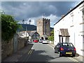
Llangattock
Looking towards the tower of St Catwg's church
Image: © Geoff Pick
Taken: 12 Aug 2010
0.02 miles
3
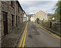
Ancient and modern, Swan Lane, Llangattock
On both sides of the lane, modern double yellow lines contrast with ancient cobbled pavements.
Image: © Jaggery
Taken: 22 Nov 2015
0.02 miles
4
Entering Llangattock from the west
The alcove in the wall contains a drinking fountain http://www.geograph.org.uk/photo/3035114 .
Image: © Robin Drayton
Taken: 30 Aug 2012
0.02 miles
5

Tower of the Grade II* listed Parish Church of St Catwg, Llangattock
Saint Catwg's church in Llangattock is about a kilometre SW of Crickhowell. The tower
is a 16th century addition to the church which was built in the 13th and 14th centuries.
There has been a church on this site since the early Middle Ages, possibly as far back
as the 6th century. The church was grade II* listed in July 1963.
Image: © Jaggery
Taken: 17 Jun 2012
0.02 miles
6

Churchyard path, Parish Church of St Catwg, Llangattock
On the right is the grade II* listed church. http://www.geograph.org.uk/photo/3035076
Image: © Jaggery
Taken: 17 Jun 2012
0.02 miles
7

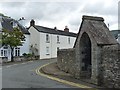
Drinking fountain, Llangattock
Erected in 1881. See http://www.geograph.org.uk/photo/3035127 for a closer view.
Image: © Jaggery
Taken: 17 Jun 2012
0.02 miles
8

Drinking fountain detail, Llangattock
The fountain http://www.geograph.org.uk/photo/3035114 dates from 1881. The large plaque repeats most of the faded original text engraved in the arch above it. The small plaque commemorates the work carried out by the people of Llangattock in formulating the first ever design statement in Wales during 1994/95.
Image: © Jaggery
Taken: 17 Jun 2012
0.02 miles
9

Road junction in Llangattock
One arm of the signpost on the right points left towards Ffawyddog (¼ mile).
Mostly hidden by vegetation, the other arm points to the right, towards Dardy.
Image: © Jaggery
Taken: 17 Jun 2012
0.02 miles
10

The Old Schoolhouse, Llangattock
The house name is in Welsh - Hen Ty Ysgol, old school house. Located at the junction of the road to Dardy and the road to Ffawyddog. The tower http://www.geograph.org.uk/photo/3035076 of the village church is in the background.
Image: © Jaggery
Taken: 17 Jun 2012
0.02 miles